


This chapter describes the physical and socio-economic environment In the project area at the start of activities in late 1981. The intent is to create a better understanding of the problems to be dealt with and to provide a baseline against which the accomplishments of the project can be measured.
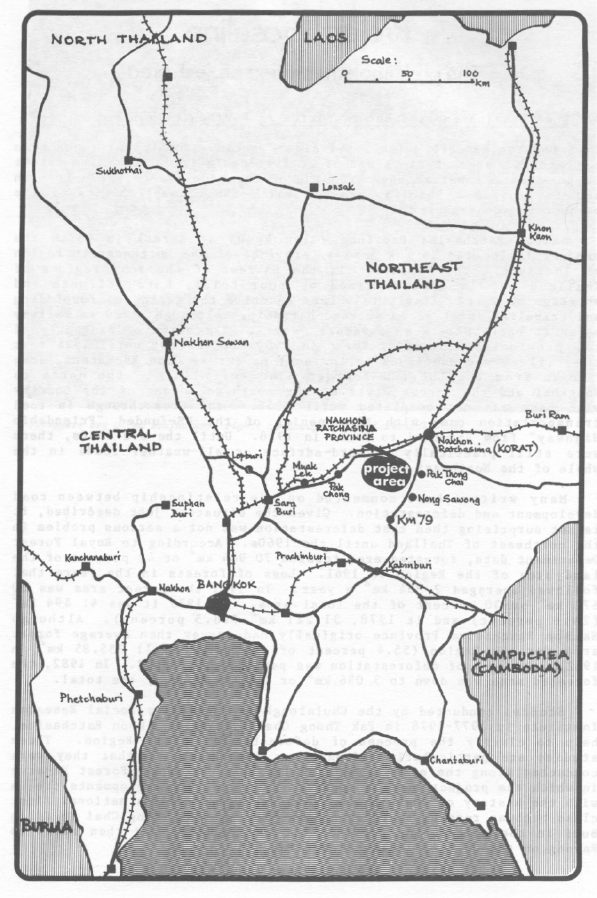
Nakhon Ratchasima Province (also known as Korat) in which the project is located is the gateway province of the Northeastern Region of Thailand. The Northeast is the poorest of the four regions of Thailand and is characterized by poor soils, harsh climate and shortage of water. Early travelers describe the region as forbidding and traveling In it as an extreme hardship. Although a 200 km railway began to operate between Saraburi (some 150 km north of Bangkok) and the provincial capital of Korat in 1900, it was not until 1926 that the railway was continued to the east as far as Ubon Rachatani, some 100 km from the Laotian boarder. The rail line to the north to Nongkhai and the Mekong River at the northern border of the country with Laos was not completed until 1955. The breakthrough in road transportation came with tie opening of the US-funded "Friendship Highway" from Saraburi to Korat in 1958. Until the mid 1960s, there were still practically no hard-surface or all-weather wads in the whole of the Northeast.
Many writers have commented on the relationship between road development and deforestation. Given the situation just described, it is not surprising then that deforestation was not a serious problem in the northeast of Thailand until the 1960s. According to Royal Forest Department data, forested area totaled 70 904 km or 42 percent of the land area of the Region in 2 1961. Loss of forests in the years that followed averaged 2 334 km a year. In 1973 the forest area was 52 671 km or 30 'percent of the total area. In 1976 it was 41 494 km (24.6 percent) and it 1978, 31 221 km2 (18.5 percent). Although Nakhon Ratcahasima Province originally had larger than average foIest area for the Region (55.4 percent of the total or 11 355.85 km in 1962), the rate of deforestation was particularly rapid. In 1982, the forested area was down to 3 036 km or 14.8 percent of the total.
Studies conducted by the Chulalongkorn University Social Research Institute in 1977-1978 in Pak Thong Chai District, Nakhon Ratchasima, help to clarify the process of deforestation in the Region. These studies are particularly relevant to the project in that they were conducted along the eastern edge of the Khao Phu Luang Forest Reserve in which the project area is located. Many of the developments tie in with the history of what is now known as Highway 304, a national first class highway running south from Korat through Pak Thong Chai to Kabin Buri in the neighboring province of Prachin Buri, and then south to Rayong on the Gulf of Thailand (See Map 1).
The first dirt road from Pak Thong Chai to Kabin Buri District was built in 1952. At that time, there were a number of settled villages in the lowlands of the area growing paddy and sugar cane. The area was entirely converted to paddy after the completion of the Lam Phra Phloeng Dam (at the edge of the project area) in 1967 when irrigation water became available. In the then heavily wooded hills, other groups practiced a highland culture. They were hunters and gatherers of forest produce such as scented wood (Hopea odorata) and lacquer which they bartered in a market center in Prachin Buri. They also practiced slash and burn agriculture and cultivated upland crops including dry rice, chilies, tobacco and taro. As these settlers exploited and cleared the forest, patches of land clearings began to appear in different locations.
At the same time, some forest area was also being eroded by wet rice farmers in villages around the periphery who cleared forestland in the vicinity to grow upland crops such as maize as a supplementary source of income. It was an attractive undertaking which involved no great hardships. The land was fertile and there was a ready outlet for produce at the Pak Thong Chai market which was not far away and reasonably accessible over the newly built dirt road. This process was a gradual one and it appears that there were no significant forest losses at this early date.
Commercial logging operations, both legal and illegal, began at an early date in the Khao Phu Luang forest. A sawmill started operating in the area (Ban Po Daeng) in 1949. Its owner and other sawmillers in Kabin Buri and Korat hired workers from Nakhon Nayok Province to the south to fell trees. Some local villagers also derived income by supplying logs to the sawmills. The logs were hauled through the forest to the road by elephants, and were then loaded onto trucks for transport to the sawmills.
In 1958, the road from Pak Thong Chai to Kabin Buri was given a laterite surface and an increasing number of simple roads and trails built by local villagers and loggers began to penetrate into the interior. These road improvements were paralleled by an intensification of logging operation. Concern about deforestation led to the first boundary surveys of the National Reserved Forest of Khao Phu Luang in 1962 but it was only in 1973 that the area was officially designated a reserved forest. A logging concession in the reserved forest area was granted to the Nakhon Ratchasima Wood Company. From 1972 to 1977, this company felled and extracted 34 500 trees from the Khao Phu Luang forest, some 36 percent of the total removals from Nakhon Ratchasima Province over the period 1972-1980.
In 1980 an inventory conducted of the 8 997 ha project area found that only 659 ha, or 7.3 percent of the project area could be classified as undisturbed natural forest, and this was mainly on rocky and hilly areas. In the period from 1975 to 1980, 1 400 ha or 68 percent of the natural forest in the project area had been disturbed, an annual rate of destruction of 10.9 percent.
Although tree felling for the lumber industry was a major factor in the deforestation of the area, the promotion of maize as a major export commodity from the mid-1950s onwards was also critical. According to
the Department of Business Economics (Ministry of Commerce), the value of maize exported by Thailand before 1957 was less than Baht 100 million (US$ 5 million) a year. By 1964, it had increased to Baht 1 147 million ($57 350 million) a. year, making it the country's third most important export commodity. Pak Thong Chai began to emerge as a maize trading center in 1957, but the rapid expansion of maize growing began in 1964. Tractors were introduced in 1966. Construction of Highway 304 began in that year and was completed in 1969. This high-way considerably enhanced the importance of Pak Thong Chai as a trading center. A second trading center emerged on the highway at Ban San Chao Pho some 50 km to the south and became known as the Kilometer 79 Market. Maize traders from other locations such as Muak Lek and Pak Chong on the Friendship Highway flocked to this market to set up maize buying depots. The maize boom peaked in 1973-1975 when maize prices on the Korat market reached Baht 2.70 ($0.135) per kilogram. Profits from maize cultivation were high in the early years as the soil of newly cleared forest was rich and yields were good even without application of fertilizer. Profits decreased considerably after 1976, however, as the soil became impoverished and as the cost of motor fuel and fertilizer rose significantly.
Precise information on the movement of the population into the forest during the maize boom is difficult to obtain but the overall picture is clear. After the original forest and plain dwellers penetrated the forest, a second group to play a significant role in the area was the road construction workers, especially those employed for the construction of Highway 304 from 1966 to 1969. Many had been maize growers who stayed behind to grow maize after the highway was completed. Through them, word spread quickly to their home villages that new fertile land was available in the Khao Phu Luang forest. The result was a large influx of maize growers who came to settle permanently on land that they either purchased from previous occupiers or cleared themselves, mainly by burning whatever trees and brush remained. The site of the project at the western end of the forest had already begun to be penetrated in the 1960s but at a much slower rate, apparently because road communication was so poor. It was possible at this time to drive a heavy duty vehicle from Pak Thong Chai through the project area to Pak Chong only during the dry season. Early settlers in the project area relate that in the mid-1960s, the site was still heavily forested and that it took a full day to reach the Pak Chong market. The rate of penetration of the western portion of the forest was presumably accelerated as a result of the construction of the Lam Phra Ploeng Dam, completed in 1967, and of the all-weather road linking it with Highway 304. The reservoir created by the dam is at the very edge of the project area. Even today, an alternative still used by the local population to travel from the project area to the town of Pak Thong Chai when heavy rains make the regular road difficult to negotiate is to go first to Khok Samran on the, western shore of the reservoir, cross the reservoir by boat, and continue on by public transportation to Highway 304.
According to Napat Sirisambhand (1978), there were three distinct types of cultivators in the eastern half of the Khao Phu Luang forest area in 1978. The first included the permanent residents described above. The second type was seasonal residents, mostly from wet rice growing areas of the Central Region (Aytthaya, Sing Burl) and the Northeast (Pimai
District in Nakhon Ratchasima, Ubon Ratchathani). They would come into the area from March to May to plant maize, then return to, their home villages from June to August to plant rice. They would come back to harvest the maize in September and October and return home to harvest their rice from November to February. Some of the seasonal residents were land owners and others cultivated rented land. Some of the land owners were said to have large holdings, renting some out and speculating in land while coming irregularly depending on the market price of maize.
The third category of cultivators was that of seasonal wage labourers. These were mostly poorer wet rice farmers from the Northeastern Region. Many came from surrounding districts of Nakhon Ratchasima Province and others were from Surin, Si Sa Ket, and Buriram. They also came during the rice off-season to earn wages in the maize fields, then going on to wet rice areas in season to seek wage labour. After some time, however, quite a few managed to rent or buy holdings of their own and become permanent residents.
According to a 1977 study of forest intruders in Tambon Sakaerat, Pak Thong Chai District, less than 15 percent of the members of the farming households sampled were born locally. About 50 percent of the immigrants came from the Northeast, mostly from tambons in Pak Thong Chal or other districts in Nakhon Rachasima. About 40 percent came from the Central Region (Lop Burl, Saraburi, Prachin Burl, Chon Burl) and the remainder came from the North (Petchabun, Nakhon Sawan).
Once maize became a major export commodity and many traders (known locally as Tao Kae) moved into the area, the Kilometer 79 Market, and Pak Chong itself became the main maize purchasing centres for the growers in the Khao Phu Luang forest area. Large-scale traders with at least Baht 500 000 (US$ 25 000 - 1978 prices) bought maize which was bulked in depots in market centres and then sent to Bangkok. As traders dealt directly with exporters, they were well informed of market prices and, in practice; set local maize purchase prices.
Small-scale traders were general merchants in market areas who also dealt in maize. Large or small, these traders played an important role in promoting maize production in the area. Not only did they purchase the farmers' production, they actually financed the farmers' operation by providing cash, consumer goods and production inputs such as fertilizer and insecticide on credit. In some cases they provided tractors to plough the fields and vehicles to transport the harvested corn to their mills. In 1978, the cash outlay needed to grow maize in the area was about Baht 2 188 ($109) per ha. Agreements entered into with the farmer stipulated that he sell all of his maize harvest to the trader (at the price set by the trader) who provided the services mentioned. When the harvest was delivered, the amount of the debt plus 5 percent a month interest was deducted from the sale price. In some instances, the farmers defaulted either because they could not or chose not to pay the debt. In this case, the farmer simply abandoned his fields. To forestall such practices, some traders sent henchmen to the farmers' fields at harvest time. Generally speaking, producers of cash crops such as maize are much more dependent on such sources of credit than rice farmers who at least produce their own food. It is not uncommon for maize traders to keep stocks of rice to supply to their clients on credit during the maize growing season.
The institution of the Tao Kae is still very much alive in the project area in spite of efforts by project implementors to encourage farmers to use the formal sector for credit in order to avoid usurious interest rates.
Even though cultivator settlers had already begun to occupy the Khao Phu Luang forest area, a 1976 US Army map based on aerial photography gives no indication of villages in the area. In early 1982, it was still difficult to identify meaningful village community units and the area was characterized mainly by scattered homesteads spread over the countryside. Local people do, however, make reference to new settlers coming in groups from the same village of origin, perhaps purchasing land together and settling down as a group. As original holdings lost their fertility, they were abandoned and new land was sought elsewhere. The most common form of penetration was for individual farming households or small groups of households to acquire land and build their huts close to sources of water or by the side of a road track. As more and more newcomers came in from different locations, each household tended to cultivate an independent and self-sufficient style of life. All spoke the same language and shared a common culture, but the bonds based on kinship and long association characteristic of older and traditional Thai rural communities were absent. There was less motivation therefore to engage in cooperative ventures serving group interests. As the population grew, new local Government administrative units were created. Thus, for example a new tambon was carved out of Tambon Takhop which formerly included much of the reserved forest area and was called Raroeng. All homesteads were assigned to named village groups and given house numbers. All village groups were required to select village headmen (phuyaiban) and to form village councils which were duly confirmed by the Pak Thong Chai District Office. It was some time before these administrative entitles took on some sociological reality, however.
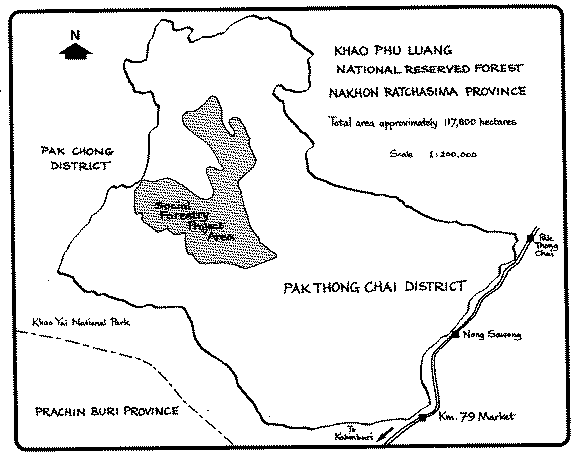
area is in the territory of Pak Thong Chai District and occupies virtually all of the newly created tambon of Raroeng and a small portion of Tambon Takhop. There is some overlapping into Pak Chong District to the west in Tambon Khlong Muang and Tambon Wang Ka Ta.
The natural vegetation of the area is dry evergreen and mixed deciduous forest. Aerial photos taken between 1975 and 1977 were used as a basis for ground checking and forest inventory on a line plot system in 1980 which resulted in the following land classification of the project area:
Class |
Percent of Total Area | |
1975 |
1980 | |
Undisturbed dry evergreen forest |
22.8 |
7.3 |
Disturbed dry evergreen forest |
1.6 |
1.6 |
Agricultural land |
41.6 |
58.9 |
Swidden areas |
33.9 |
32.0 |
Water resources |
0.1 |
0.1 |
The remaining forest supported an average of 59 trees per ha and 30m3 per ha of marketable timber volume, showing the low quality of even the undisturbed forest. Forests were rapidly becoming disturbed while disturbed forestland was being converted to agricultural use. Illegal felling by timber merchants, farmers and charcoal producers was widespread. The disturbed forest contained hardly any trees of commercial value. Some of the agricultural land and swiddens had recently been abandoned due to soil exhaustion and were being invaded by imperata grasses.
A soil capacity study using aerial photos, army maps and ground survey was carried out in 1980. Borings, pits, roadcuts, excavations, etc. were used to evaluate the soils of the area. Land use classes were identified and a theoretical land use plan was drawn up as follows:
(1) 18.1 percent of the area (1 705 ha) consists of mountainous and hilly slopes with gradients exceeding 16 percent and should be kept under permanent forest cover to prevent erosion. 148 ha of disturbed dry evergreen forest on slopes steeper than 35 percent, on rocky outcrops and river banks are to be enrichment planted without felling the existing cover. The remaining 654 ha of undisturbed forestland is to be retained and protected. The rest of the area is to be planted with forest trees.
(2) 21.6 percent of the area (2 039 ha) consists of soils which are shallow, of poor fertility, or on slopes. It is to be used for forest plantation of fast growing tree species with some agroforestry.
(3) 32.1 percent of the area (3 020 ha) consists of shallow slopes or soils which may become degraded. Recommended use is a mix of perennial fruit trees, annual crops and village woodlots. Good management is necessary to maintain soil fertility.
(4) 28.2 percent of the area (2 658 ha) is made up of flat land with deep soils and should be used for permanent agriculture. Limitations of fertility, soil structure and erosion must be taken into account and the land managed accordingly.
A survey conducted in 1979 put the population of the area at about 249 households or 1 560 individuals. According to a 1982 survey, the number of households was 1 293 for a total population about 8 000. Although under enumeration seems probable in the case of the 1979 survey due to the physical difficulty of conducting the survey -- poor or no roads, dispersion of homesteads, security problems, etc. -there are reasons to believe that there was a highly accelerated inflow of population between the two studies. Some 1 000 people had recently been evicted from Ban Nong Takhu, a security sensitive location some 25 km from the project area. Some old residents of the project area with large holdings reported selling portions of their land to relatives, friends and others who moved in. By this time the Lam Phra Ploeng Dam and water reservoir at the eastern edge of the project area and its access road had been completed, making the area more attractive to prospective migrants. According to the 1982 survey, 69 percent of the residents interviewed had migrated to the project area in the preceding one to two years while the remaining 31 percent had been there three years or more, some for as long as 30 years.
The village structure of the project area was still very amorphous and as new settlers moved into an area it was not always clear to which administrative villages they belonged. Village territorial boundaries were vague and there was little sense of community identification due to the dispersion of homesteads and to the problems of group formation among unfamiliar people. Only 25 percent of the men interviewed had participated in the activities of any village organization. Because of communications difficulties, there was very little contact with local Government authorities at the district and provincial levels or with Government officers providing development services such as agricultural extension.
Although the communities described had little in common with traditional long established rural communities, their culture was remarkably homogeneous. All spoke central Thai as as well as the Korat version of the northeastern dialect. All adhered to the beliefs and practices of rural folk Buddhism which also included animistic or Brahmanical rituals associated with agricultural and life cycles. There was relatively little temple-centered religious observance but this was because temples were few; many temples were built in the two or three years that followed. The world view profile of this population provided by the social survey is typical of Thai rural people generally. Given the commonalities, there were grounds to hope that, given time, these people would cease to look upon one another as outsiders and that their villages could evolve gradually into more normal and functional communities.
The families in the area at the start of project activities were predominantly (85 percent or more) nuclear rather than extended families. The average age of the household head respondents to the 1982 social survey was 41.6 years. Sixty five percent of their spouses were in the 20-39 years age group, hence ín the child-bearing period. This is of particular significance given the fact that families were already large with a mean of 4.7 children per family.
The level of education was generally low; 11 percent of the household heads and 19 percent of the spouses had never attended school and of those who had attended school, the overwhelming majority had completed less than four years of primary schooling. There were three elementary schools in the area at that time.
Information on the physical living conditions of these households is provided by a village study conducted in a new community in the area (Ban Sai Ngam) in September 1984. At that time, over 90 percent of the households lived in houses of their own which had been built from local lumber. Although it was illegal to fell trees for this purpose,
the practice was tolerated as there were no other options available to the villagers in the way of building materials. About 60 percent of the houses had corrugated metal roofing and the remainder had thatch roofing. The main disadvantage of the latter was that it could not be used to collect rain water, the main source of drinking water in the area. If a household had enough pottery or cement jars to collect rain water in season, there was enough to supply the family for the whole year. Otherwise, water had to be drawn from ponds and streams, which was a health hazard as such water was not treated before being consumed. - Fewer than 10 percent of the homesteads had toilets of any kind. Garbage was usually disposed of by burning.
Eighty-three percent of those surveyed replied that their diet consisted principally of rice, vegetables and chili sauce. Those living close to streams had better access to fish. Native chickens raised in relatively large numbers were as a source of meat and eggs. Breast feeding was the norm for infants. but more than 50 percent of them received weaning foods such as banana and rice earlier than four months and 35 percent were given such foods in the first month of life.
Common ailments in the area at this time were malaria, influenza and stomach disorders. Adults appeared to suffer more from malaria (52 percent of the sample) than from influenza (28 percent). Among infants the tendency was reversed, the incidence of influenza was 67 percent, and that of malaria was 23 percent. The villagers would attempt self treatment using medicines purchased from village stores when such illnesses occurred. If this failed, there were two Government-supported health centers in the project area, one at the tambon seat, Ban Raroeng, and the other, a malaria identification and eradication center, at Ban Khlong Kum. However, 'given the level of services provided and the desperate lack of medicines, the seriously ill were compelled to visit the hospitals in Pak Chong or Pak Thong Chai for treatment. This situation notwithstanding, only 5 percent of the sampled households reported a death among its members during 1981.
More than 60 percent of all children were born in the home with traditional granny midwives and/or husbands in attendance. The remainder were handled by trained personnel, usually in health stations, clinics or hospitals, but sometimes at home.
Notwithstanding difficulties of road communication, all reports on the population of the project area at this time indicate that it was not isolated and was subjected to considerable urban influence. Most farmers traveled to the Pak Chong market area frequently to get supplies either for crop production or for home consumption, or to deliver crops at harvest time. They also presumably had to stay in touch with their Tao Kae patron in Pak Chong, the rice trader with whom they had contractual arrangements for the provision of credit and the sale of their crops. It appears that they also went to Pak Chong for recreational purposes, for example, to visit cinema halls. The cinema was already a favorite form of entertainment and open-air all-night showings of films organized by outside entrepreneurs in the project area villages were already fairly frequent. There were also battery-operated TV sets in local shops where villagers could watch news broadcasts and movies.
The 1979 and 1982 surveys both provide information on the amount of land occupied for farming by households interviewed in the project area. According to the December 1979 survey, none of the farmers interviewed held less than 10 rai (1.6 ha) of land. Farmers were grouped into two categories, those holding from 10 to 49 rai of land (79 percent of the sample), and farmers holding 50 rai (8 ha) or more. Table 2 which summarizes this data shows significant changes over time. The first is the emergence of a category of marginal farmers holding less than 10 rai. In 1982, they were 15 percent of the sample with a mean size of holding of 5 rai. Second, the proportion of large-scale farmers had decreased from 21 percent to 12 percent and the mean size of their holding was 59.5 rai (9 .5 ha). There appears to have been a rapidly increasing rate of migration.
The overall distribution of farmers sampled in the 1982 economic survey into marginal, small (10-19 rai), medium (20-49 rai), and large farmers is shown in Table 3. The mean size of holding for the whole sample was 24.9 rai (4.0 ha). It was estimated that in 1981, the land occupied by some 1 300 farming households was about 30 300 rai (4 848 ha). This was 85 percent of the land considered suitable for agriculture.
From the point of view of the size of farm holdings, the situation of the farmers interviewed appeared fairly satisfactory in 1981. However, although most farmers interviewed in 1982 claimed ownership over some or all of the land they farmed, in fact, all these claimants were liable to be evicted as they were illegal squatters on public land -- National Reserved Forest. It should be noted, however, that claims to ownership were recognized by the local population so that the claimants could dispose of their land just as any other owner would -exploiting it, selling it, renting it out, giving it in inheritance to heirs, etc. Almost one half of these "owners" even paid the land tax for their holding at the District Office and the fact that this was accepted and a receipt issued for the payment was taken as at least implicit recognition by a Government office of their rights as owners. The discussion of ownership that follows should be interpreted in the light of these qualifications.
Of the 2 982 rai (477 ha) of land occupied by the farmers interviewed in 1981, 2 639 rai or 89 percent were owner-operated and the remaining 11.5 percent was either rented or used rent free. Of the sampled households, 19 percent claimed that they rented land ranging from about 5-45 rai.
A question often raised in relation to encroached land, especially when large tracts are involved, is the extent to which such land is actually put to use or, relatedly, the extent to which the encroachers have the ability to effectively crop the whole area. The implication is that if they cannot effectively make use of the whole area, a portion should be made available to others who have little or no land.
According to the 1982 survey, the area occupied was 2 982 rai (477 h a) while the area cropped was 2 689 rai (430 ha). However, two crops of maize were harvested in a year and both crops may have been grown on the same plot. This would mean the area of holdings that was used in fact to grow crops (maize) was actually smaller than the figures given above for area cropped. How much land actually lay fallow is not known.
In the 1981 crop year, although other crops such as cassava, cotton and mung bean were grown, this production was negligable compared to that of maize. Maize was by far the most important single crop and the main source of income. Two crops were grown a year and even without the application of fertilizer, yields averaged about 470
kg/rai (75.2 kg/ha). Maize yields for Nakhon Ratchasima Province as a whole were 130-320 kg/rai (20.8-51.2 kg/ha) which indicates that soils in the project area were still relatively fertile. The mean annual production of maize per household was 8 800 kg but, for 37 percent of the 108 maize producers surveyed, the annual production was less than 4 000 kg. The total maize production of the sampled farmers in 1981 was 1 020.8 metric tonnes of which 8 903.7 tonnes or 89 percent was produced for sale. The balance was stored at home for use as seed in the following planting season. It was estimated that the total quantity of maize produced and sold by all farmers in the project area was about 9 474 metric tonnes.
Approximately 20 percent of the sampled households had fruit trees on their land covering areas of from less than one rai to two and one-half rai. Most households raised native chickens on their homesteads in fairly large numbers: 17-44 per household according to the survey report. The report makes no mention of cattle but some were certainly raised as bullocks were still commonly used with ox-carts; however, these were rapidly being replaced by tractors to plow the fields. Fish were caught and trapped in the several streams in the area.
A small percentage of the population was made up of non-farmers. According to the 1982 survey data, 6 percent of the sampled households did not occupy farm holdings. They were casual labourers, storekeepers, carpenters, tractor operators, etc. About 30 percent of the farmers interviewed engaged in non-farm work as a subsidiary occupation, especially outside of the cropping season.
There is a huge demand for agricultural labour during the maize cropping season for planting, weeding, and harvesting. In 1982, labour was the farmers' second largest expense item after tractor hiring and averaged Baht 2 709 (US$118) per household per year. The cost of hiring agricultural labourers was about Baht 30 per day at that time and household demand was 90 man/days per year, not including the contribution of unpaid family workers. It seems likely that the project area labour force could not satisfy this seasonal demand for agricultural labour at a time of peak demand and workers belonging to the category of seasonal wage labourers had to come in from elsewhere.
The writers of the economic survey report estimated the mean household gross annual earnings for 1981 to have been approximately Baht 15 700 ($686) of which Baht 14 575 or 93 percent was derived from maize production. The other components were income from other agricultural activities (Baht 121) and non-farm income (Baht 1 004).
However, based on the maize production data cited earlier, household income from maize in 1979 for 37 percent of the growers interviewed was less than Baht 8 000 a year and for almost 10 percent i t was less than Baht 2 000. For these small producers to survive, the share of household income from non-farm employment had to be significantly higher than the average. Per caput income of the sampled households was only about Baht 2 175. This 1979 figure was less than half (44 percent) of Bank of Thailand figures of the same year for the Northeastern Region which itself was the poorest region in the Kingdom, averaging only 18 percent of the national figure.
Three items dominated the maize production expenses of most of the farmers interviewed: tractor hiring, labour, and transportation of the maize harvest to the market outlet. Average per household expenditure for these items was Baht 3 360 ($146), Baht 2 708 ($118), and Baht 1 536 ($67) respectively, for a total of Baht 7 604 ($331) per year. Other production expenses were relatively insignificant and can be disregarded in the calculation of a rough estimate of the mean farm household net income which would then be about Baht 7 500 ($326) per year. Fertilizer was not used and insecticide was applied in minute quantities and usually for crops other than maize.
Recurrent household expenditures listed by the social survey report in order of magnitude were food, medicine, clothing and schooling. An average family would consume one tang (15 kg) of rice per week. At 1981 prices, a year's supply of the cheapest quality of milled rice would represent an expenditure of about Baht 3 960 ($170), already more than half of the mean household net income of the sample households.
It follows then that farmers in the lower and average income ranges had exhausted all of their earnings by the end of a cropping season. They were therefore completely dependent on creditors to obtain cash advances to pay for tractor hire and labour to initiate a new cropping season and perhaps even to buy food. In 1981, the only source of credit available was the informal sector and normal rates of interest were 5 percent per month. Only 21 percent of the farmers interviewed had no debts with roughly the same percentage having savings of over Baht 2 000 ($87). These, one would assume, were all large farmers with holdings and income well above the mean of the sample.
