


Forest resources in Rwanda have steadily decreased over time, especially since the beginning of this century, due to rapid population growth1, a limited land base and growing competition for resources. But, in spite of dwindling tree resources, the cultivation and management of woody species remains important in Rwandan farming systems. Trees are the primary sources of energy and construction material. Their cultivation is encouraged to prevent soil erosion, to increase soil fertility through mulching and green manure, and to provide products such as fruit, medicine and fibres. Over time, farmers have generated extensive knowledge about the management of indigenous tree species for these purposes. In addition, they have acquired and adapted knowledge about exotic species and silvicultural practices introduced since the 1930s. However, researchers have generally paid little attention to farmers' knowledge-building processes which allow them to adapt to environmental, political and socio-economic changes. Surveys, rapid rural appraisals and agro-ecosystem analyses done by numerous development projects in the country have basically given the impression of stable and static agricultural and agroforestry systems because they have only dealt with one point in time.
The goal of this case study2 is to examine the historical and contemporary processes involved in the generation and adaptation of agroforestry knowledge and technology by farmers in Rwanda. It does not aim to describe existing agroforestry systems, although some description is necessary to understand the processes of knowledge building. What farmers know is a reflection of what they do and vice versa. Thus, there are extensive interactions between the processes of knowledge building, existing knowledge and the actual agroforestry practices observed in farmers' fields.
It is important to know the inner workings of the endogenous knowledge system, who the experimenters are within the system, and what their objectives and methods are, in order to improve the integration of agroforestry and tree planting policies and practices in each country, and its agrarian economy (CTA, 1988). Plugging into existing networks of experimenting farmers and thus choosing people already familiar with experimentation can reduce the cost of on-farm research.3 This can also help improve the designs of both on-farm and on-station experiments. Building links between farmers' endogenous knowledge systems and researchers' scientific knowledge systems can lead to synthesis between them. That synthesis will strengthen, empower and legitimize endogenous capacities for identifying problems and developing solutions and will be an important step toward enabling rural people themselves to alleviate their poverty.
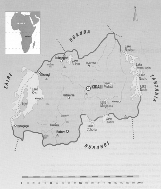
Rwanda is located in eastern Central Africa, bordered by Uganda, Tanzania, Burundi and Zaire (see Map 1).
Of a total area of 28 338 km2, approximately 18 725 km2 is usable for agro-sylvopastoral activities (Djimde, 1988). The remainder is national parks and natural forest areas. Estimates of the amount of land being cropped vary from about 8 000 km2 in 1970 (Delepierre and Prefol, 1973; World Bank, 1977) to 13 500 km2 (Niang and Styger, 1990). The additional land is being cropped at the expense of natural forest areas, pasture land and land only marginally suitable for cultivation (i.e. land on very steep slopes, highly readable land and the very acid, low fertility soils of the ZaireNile Divide).
Estimates of forest land range from about 126 000 ha (World Bank, 1977) to 225 000 ha (Sorg, 1980). Both estimates include natural forests as well as forest plantations. Using an average of these two estimates and a population of 6 million, Niang and Styger (1990) evaluated the area of forest available per inhabitant at 0.3 ha. Wood is used for 95 percent of Rwanda's energy needs, particularly at the household level.
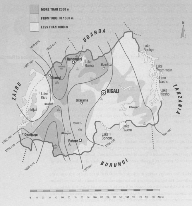
Relief: The country ranges in altitude from 1 000 m in the east to 4 500 m in the northwest. The highest peaks are the Birunga volcanoes found in Volcanoes National Park which straddles the border of Rwanda, Uganda and Zaire. It is the home of the famous mountain gorillas. A 160 km mountain range in the western part of the country forms the division between the Zaire and Nile watersheds (see Map 2).
A series of long, sharply-defined hills, with steep, convex slopes and flat ridges are intersected by deep valleys, the bottoms of which form marshy plains. These steep slopes do not prevent farmers from using the land for cultivation. The steepest slopes are found along the Zaire-Nile Divide and in the northern highlands. Seventy percent of the area cultivated has slopes greater than 10 percent. Fields on five percent of the cultivated area have slopes greater than 80 percent (Rossi, 1984).
Climate: Rwanda is located just south of the equator. Because of its high altitude, its temperature and rainfall are more moderate than the surrounding hot and humid equatorial regions, even though the climate follows the same annual cycles. Average temperature on the central plateau is about 19-20° C and changes about 0.5° C with every 100-m change in altitude. Temperatures are rather stable, with small annual variations.
Precipitation increases with higher altitudes and varies from about 800 mm in the east to about 1600 mm in Volcanoes National Park (see Map 2). Rain falls in a bimodal pattern. In the first rainy season (September to December), about 27 percent of the total annual precipitation is recorded. This is followed by a short dry period (mid-December to January) during which rains do not stop completely except in the eastern part of the country, but slow considerably. Forty percent of the annual precipitation falls during the long rainy season (February until mid-May or early June) followed by the long dry season which lasts from two months in the northwest and on the ZaireNile Divide to four months in the east (mid-May to mid-September).
Population: Rwanda has one of the world's highest population growth rates (3.1 percent). Its population density of 252 persons per km2 is comparable to Bangladesh. According to the 1991 census, Rwanda has a population of 7.1 million, 2.3 million more than in the 1978 census. The population is not evenly distributed over the country and local densities may be as high as 800 persons per km2 agricultural land.
Ninety-five percent of Rwandans live mainly from subsistence farming. The largest city, the capital Kigali, has about 200,000 inhabitants. As early as the 1920s, Belgian colonial rulers predicted wide-spread famines in Rwanda because of the rapidly-growing population, which at that time was between 1.5 and 2 million, and severe land degradation due to over-cultivation and deforestation. In spite of these predictions, agricultural production of subsistence crops broadly kept pace with population increases until about 1977, mainly by expanding to new land in the east and by draining the previously uncultivable valley bottoms. Since then the area of land annually made available for subsistence crops has increased by only 1.4 percent (Reyntjes, 1991) and crop yields have decreased because of erosion and declining soil fertility.
Economic conditions: According to 1989 estimates, gross national product (GNP) was equivalent to US$ 310 per capita. These same estimates pointed to an annual 1.3 percent increase in GNP although on a per capita basis the GNP declined by 1.9 percent during that same period.
The agricultural sector accounted for about 40 percent of Rwanda's gross domestic product and 91 percent of the labour force in 1989. About 95 percent of the total value of agricultural production is provided by subsistence crops including, in order of importance, bananas, sweet potatoes, cassava, beans, sorghum, rice, maize and peas. The major export crops are coffee (65 percent of export revenue in 1990) and tea (21.5 percent of export revenue). Until the mid-1980s, there was considerable revenue from pyrethrum (Rwanda was the third largest producer in the world in 1980) and quinquina, but production and revenue of both these crops has severely declined.
Rwanda's small industrial sector is dominated by processing plants for coffee, tea, sugar and tobacco, and a brewery. The country has mineral deposits, mainly gold, tin and wolframite, but its long distance from any ports (Mombasa, Kenya is 1200 km away) and volatile world prices make profitable exploitation difficult.
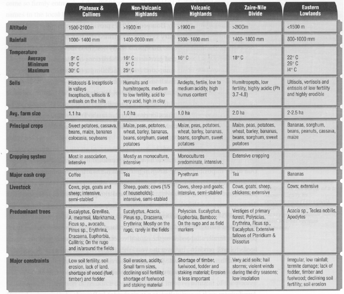
Land use systems and their principal constraints: There have been several attempts to divide the country into areas with similar characteristics in order to facilitate agricultural policy and development planning. The most widely used is the agro-ecological zones defined by Delepierre (1974). He distinguished twelve north-south zones based on topography, soils, altitude and precipitation but did not include farm crops or animals.
To assess the potential for agroforestry, however, it is necessary to consider not only biophysical conditions but also socio-economic factors, present land-use patterns, cropping systems and trees. A nation-wide diagnosis and design (D&D) exercise conducted in 1987-88 by ICRAF, with the help of the Institut des Sciences Agronomiques du Rwanda (ISAR) and the Université National du Rwanda (UNR), divided the country into five zones, namely Plateaux et Collines, Non-Volcanic Highlands, Volcanic Highlands, the highlands of the Zaire-Nile Divide and the Eastern Lowlands. Table 1 provides an overview of the major features of each zone, its farming systems and the major constraints which could potentially be solved by agroforestry.
Soil erosion, declining soil fertility and shortage of wood for fuel, timber and staking material are major constraints throughout the country. In spite of considerable development efforts for more than 50 years, these problems remain similar to the ones identified by Belgian colonial rulers in the 1920s and 1930s (Thomas, 1940, Tondeur, 1937) except for the occurrence of periodic famines.
An arboretum was established at Ruhande in 1932 to identify suitable species to reforest the countryside and prevent erosion and soil fertility decline as well as to provide various wood products to the local population. Similarly, the Belgians introduced a number of new crops, both subsistence crops (cassava, vegetables, potatoes) and export crops (coffee, tea) to combat Rwanda's frequent episodes of famine in the first decades of this century (Fallon, 1930). These introductions have had a profound effect on the agricultural systems of the country, in terms of crops produced and woody vegetation found in the landscape. The present acceptance and cultivation of cassava, eucalyptus and grevillea introduced at that time provide evidence of the changing nature of agroforestry systems, point to the necessity of agricultural research to bring about such changes, and provide an example of how the successful blending of en- dogenous and exogenous knowledge can make new technologies and crops work in the local context.
SOURCE: Djimde 1988; Niang & Styger 1990
Deforestation is believed to have begun in Rwanda as far back as 3000 BC and was
well underway before the Tutsi pastoralists arrived in the 1500s. By the early 1900s, dense forests had decreased to about three percent of the Rwanda-Urundi4 territory, or 6.5 percent if including the savanna areas (Everaerts, 1939). Colonial agronomists often considered trees more of an obstacle than an aid for agricultural development and, other than fruit trees and a few economic woody species such as coffee, tea, and oil palm, they made no mention of trees in their descriptions of the farming systems (see for example Mortehan, 1921 and Everaerts,1939).
A later ethnographic study by Bourgeois (1957) provided more extensive information on traditional agroforestry systems, confirmed the lack of economic woody species in the farming systems. Bourgeois' study described the planting and use of several indigenous species and gave detailed descriptions of trees and shrubs planted in and around the home compound (rugo), including a number of species propagated by planting large leafless branches.5 The latter were often used to build dense enclosures to protect against animals and thieves but also provided food; wood used for cooking, construction and fabrication of utensils and tools; bark for fibre to make clothing and rope; and medicines for people and animals. Trees within the compound were primarily planted for timber. No information was given about the use of woody species outside of the compound.
Reforestation and tree cultivation have been promoted in Rwanda since the 1930s. Due to the imposition by the Belgian territorial administration, numerous rapidly growing exotic trees (eucalyptus, grevillea, black wattle, cypress, cassia, etc.) were planted in community and private woodlots and along contours as a means to limit deforestation, provide fuelwood and timber, and help combat soil erosion (Lens, 1949; Dubois, 1954; Languy,1954; Derenne,1989).6 In spite of severe deforestation, the cultivation and management of woody species on farm actually increased. Before Independence, farmers depended on the natural vegetation in the landscape to meet their needs for tree products, but over the years they began to plant and manage trees and shrubs on their land to provide products and services such as fruits, fuel, medicines, fibres, fodder, fences, boundary markers and staking materials.
Agroforestry, as it is now called, is not a new idea in Rwanda. An extensive knowledge system has developed around the incorporation of both indigenous and exotic trees in its farming systems, especially during the last 30 years. For example, Balasubramanian and Egli (1986) found that 86 percent of the farmers in the BugeseraGisaka-Migongo (BGM) region of southern Rwanda had an average of nine fruit trees (avocado, citrus, mango, guava, jack and passion fruits) on their farms, in addition to many other species (Eucalyptus, Grevillea, Ficus sp., Sesbania, Cassia, Markhamia, etc.). Hummel's research in Muyaga (Butare Prefecture) counted an average of 89 trees per farm (84 per ha).
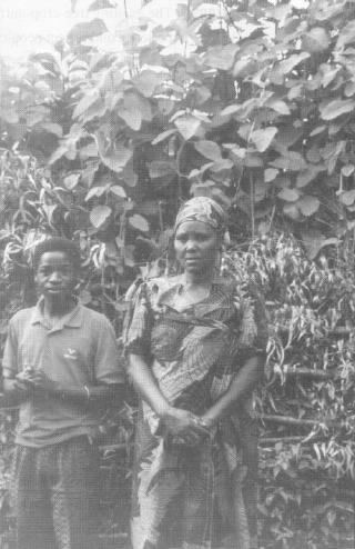
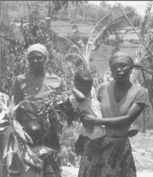
These people are standing against the backdrop of a tree known locally as umuravumba (Tetradenia riparia). It is widely known locally as a medicinal plant, used to treat various illnesses.
Farmers' knowledge has become more extensive over the years as they have become tree producers as well as tree consumers and as ideas from outside have been incorporated into the local knowledge system. Farmers now plant exotic fruit trees such as mango, avocado and prune, and timber/fuelwood species such as Grevillea, cypress and Eucalyptus. Some of these species have become so firmly entrenched that farmers have given them names in the local language (umuzonibari /cypress and inturusu/eucalyptus).
Rwanda's oldest agroforestry project, the GTZ financed "Projet Agropastoral de Nyabisindu", which started in 1969 and was still operational in 1992, promoted the use of trees on farms as a low-input, ecologically sustain able method of agricultural development. The project served as a model for agroforestry projects elsewhere in
Africa and has been described extensively in the literature. Since 1980, many other projects in Rwanda have had agroforestry components or were established to promote agroforestry systems in a particular area of the country (CARE-Gituza and Muhura/Ngarama projects in Byumba, the BGM project in Kigali/Kibungo, Swiss
Aid Projet Pilot Forestier in Kibuye, UNDP/FAO Projet d'Intensification Agricole in Gikongoro, USAID Farming System Research and Natural Resource Management projects in Ruhengeri, etc.). These projects have been successful in developing agroforestry technologies or what Thrupp (1989) called "scientized packages". They work under research station conditions and with large inputs of technical assistance but there have been low rates of adoption of the packages as a whole (Kerkhof, 1990; N'Diaye, 1988), even though farmers do plant large numbers of trees. The low success rate, as elsewhere in Africa, has been due, mostly, to the imbalance of technical and social expertise (oversimplification of production systems, `homogenization' of landscape, acceleration of resource degradation and impoverishment of the poorer farmers, especially women) and from lack of accountability to their rural clients (Rocheleau et al., 1989). For example, in Rwanda most projects emphasize alley cropping using leucaena, sesbania or cassia, and thereby neglect any locally-developed systems that integrate indigenous species into the landscape. Given a choice and without pressure from (project) extension agents, farmers appeared to favour fruit trees or Eucalyptus and Grevillea for timber production instead of leguminous species for soil fertility and fodder (Kerkhof, 1990).
The existing tree-crop-animal systems of Rwanda have evolved from centuries of experience and reflect peoples' needs choice of plants and animal species, and their ideal spatial and temporal arrangement. Even though the systems are "not well-managed agroforestry systems" (Balasubramanian and Egli, 1986) as defined by outsiders, they are not necessarily bad, static nor unchanging. From the local point of view, they offer the best that can be achieved to guarantee a sustainable, albeit minimal, subsistence income and food supply.
Thus, for agroforestry to be relevant as an approach, it needs to be implemented with sensitivity to peoples' needs, priorities and sociocultural and economic conditions. Surveys can assess existing farm situations and determine peoples' needs, priorities, problems and constraints, but they have three major limitations: (1) they provide only a static picture (a snapshot) of a situation at one point in time; (2) they do not reveal the context of the needs, priorities, problems and constraints; and (3) they do not give an historical account of why particular systems exist and farmers' roles in developing those systems, as producers of crops and livestock as well as landscape managers and reproducers of the systems. That is why it is important to determine how such systems and technologies came into being, what the meanings are that people assign to them, how the knowledge upon which they are based is generated and how they evolve because of changes in sociocultural, economic, political and environmental conditions. When viewed this way, the systems appear to be in almost perpetual flux to meet new needs and adapt to ever-changing conditions.
This case study concentrates on the active role of farmers who take existing ideas, technologies and uses and then experiment to arrive at new ideas, technologies and uses that optimize integration of woody species on their farms. It also focuses on the time and space needed to adapt agroforestry practices within prevailing and evolving socio-economic, cultural and political conditions. The active role of farmers in these efforts should be seen as diametrically opposed to the passive adoption of externally-developed technology packages from the formal research/extension establishment. However, such technology packages (e.g. alley cropping) are not entirely useless, even though they may have very low adoption rates. They are often a prime source of inspiration and material for farmers who tinker with them to make them work in their own farm conditions or develop new technologies on the basis of them (Sumberg and Okali, 1988). The numerous exotic crops, fruit, timber and fuelwood species introduced by Belgian researchers that now form common elements of the farming systems attest to both the extensive tinkering of the farmers and the usefulness of scientific research.
The basic assumption underlying this case study is that not all farmers have the same propensity for experimentation and risk-taking because of differing socio-economic and political positions within the community and differing biophysical conditions on their farms. Neither does every farmer have the same aptitude towards experimentation and innovation. Thus, different farmers experiment with different technologies, methodologies and approaches. Even if farmers experiment with the same technology or basic idea (i.e. a certain tree species), they may arrive at completely different solutions. A pastoralist may emphasize leaf and pod production while a sedentary farmer may be more interested in timber.
The following questions guided the research and aimed at understanding farmers and their experimental practices within the changing agricultural landscape of Rwanda.
1. How have tree growing practices changed over time, in general or as a result of experimentation?
This question includes such topics as species choice, arrangement, uses, placement, management, intercropping practices and interactions between trees, crops and animals. While the answer to this question could be a case study in itself, this information is needed to build a frame of reference in which to place the other questions.
2. Who are the experimenting farmers and what differentiates them from other farmers in the community?
This includes socio-economic status, farm size, land quality, external sources of income, travel, gender, connections, political position and aptitude.
3. Why do farmers experiment? What are their objectives for experimentation?
4. Where did the idea, practice... forming the basis of the experiment originate?
5. How do farmers themselves define "experimentation"?
a. Are there common elements in the methodology experimenting farmers' use?
b. What, how, why and how long was testing done before adoption or rejection?
c. What are the adoption/rejection criteria (why or how is a particular practice better or worse than existing practices)?
d. When and under which conditions can a new practice or technology be used?
During a visit to a woodlot to discuss its history and inventory its trees, the woman pictured here (centre) with her daughter and grandchildren, collected medicinal plants. Although the greater part of the woodlot consisted of Eucalyptus spp., a part was left under natural vegetation especially to preserve its many medicinal trees and shrubs and to attract wildlife (which were occasionally trapped for food). The farmer left the woodlot open to enable people to collect medicinal plants as needed
This case study consists of eight chapters. Chapter I introduces the topic, the basic characteristics of Rwanda and the history of its tree growing practices. Chapter II addresses the methods used to study and understand the agroforestry knowledge-building processes. Chapter II also explains the choice of study areas: Maraba and Simbi districts (secteurs) located in the municipality (commune) of Maraba (Butare Prefecture); and Kibingo district in the municipality of Karama (Gikongoro Prefecture). Chapter III describes their characteristics and major features.
Chapter IV focuses on the farmers who participated: 44 locally-identified tree experts (i.e. farmers highly knowledgeable about trees and tree cultivation) and 70 comparison farmers. The chapter analyses a socio-economic survey of demographic characteristics, education, socio-economic status, farm size, land quality, livestock, external sources of income, political position and connections.
Chapter V is based on extensive discussions with farmers and presents their perspectives on historical agroforestry practices and present possibilities and reasons for practising agroforestry. It also looks at tree cultivation practices in relation to gender and farm size and presents the results of a tree inventory that shows the richness and complexity of contemporary agroforesty systems. The diversity of these systems shows that multiple solutions are possible even though they are based on similar principles that come from a small but expanding knowledge base. Experimentation is not so much carried out for the development of a specific agroforestry system, but to gain new knowledge about trees, their utility and their interactions with crops, soils and animals.
Chapter VI discusses knowledge and experimentation. Since experimentation is above all a knowledge-generating process, the farmers' connotations of "knowledge" and "being knowledgeable about agroforestry" are explained, followed by a discussion of farmer experimentation.
Chapter VII covers farmers information gathering/sharing. Farmers acquire new knowledge and technologies from a variety of sources, but not all farmers have equal access to nor are equally active in seeking out new information, discussing problems or sharing experiences. Chapter VII examines farmers' knowledge acquisition in three categories: the active seeking of new species and ideas during travel; the passive acquisition of species and tree management ideas from visitors to the farm (eg. researchers, extensionists, friends, etc); and cooperation with development or other agencies for on-farm testing of new practices. This chapter also describes how farmers share experiences with new species and methods, and the accessibility of help from extension or specialists.
The concluding chapter summarizes the key findings related to the strengths and weaknesses of farmer research, gives recommendations to enhance farmers' knowledge building and communication processes, and gives an overall conclusion.
It should be noted that none of the chapters specifically addresses research question 1: How have tree growing practices changed over time in general or as a result of experimentation? However, the information obtained from this question is woven throughout to provide the context in which the other questions are placed.
1 The population density in 1948 was 77 persons per km2, 150 per km2 in 1970, and 277 per km2 in 1990.
2 Participants in an international seminar on agroforestry at Kigali, Rwanda (CTA, 1988) recommended the study of farmer-based processes of innovation as the main strategy to further agroforestry practices in Africa.
3 For examples of such participatory technology development, see Chambers et al., 1989; Farrington, 1988; Farrington & Martin, 1988; Rhoades, 1987.
4 Ruanda-Urundi was the name of the Belgian protectorate. In 1962, the territory was split into two independent countries, Rwanda and Burundi.
5 The species so propagated were not identified. The author gave the impression that all species planted in dense hedges around the compound were propagated by branch cuttings, which may or may not have been the case.
6 Everaerts (1939) estimated the total area reforested at the end of 1938 at 22 000 ha, 9 723 ha in Ruanda and 9 878 ha in Urundi, the difference being tree plantings along roads and private woodlots. Communities were obliged to establish one ha of forest per 300 people each year in order to combat a shortage of fuelwood and timber as well as to combat the irregularity of rainfall (although Everaerts admitted that this would take thousands of hectares to accomplish).
