


This is a vitally important stage of a rapid appraisal, and it is usually poorly done. "Rapid" refers to the field operation; it should not apply to the preparations. The appraisal should be scheduled several months in advance and someone, a consultant or a forestry department staff member, should be responsible (and paid) to ensure that the pre-fieldwork information gathering is done well. This can greatly enhance the quality of the appraisal.
A rapid appraisal is necessarily confined to an area which can be covered in a few weeks' time, and is hopefully representative. The appraisal area may be as small as a few square miles around a community already selected as a pilot area, or may range over a hundred square miles. Sometimes one of the purposes of the exercise is to select a site to initiate project activities. In this case, one wants to avoid doing the appraisal in an unusual and localized situation as representative of the proposed project area. In a community forestry appraisal, this usually means representative of a particular ecological or agro-climatic zone which has been proposed for a community forestry initiative. But tenure is also a factor to be considered in seeking "representativeness." Is the tenure system in a proposed appraisal area representative of the proposed project area? Generally, if the area is ethnically uniform, and a fairly standard farming system prevails throughout, the chances increase that tenure arrangements are reasonably uniform over the area. But if there are different ethnic groups within the project area, the operating assumption must be that the tenure systems are different in important ways. Tenure systems are a product of culture as well as ecology, and the appraisal effort should touch on each ethnic area. Similarly, if there are different farming systems within an otherwise uniform project area, these differences may have given rise to different tenure phenomena. Even in an apparently uniform area, access to a market may, for example, have a diversifying effect by causing land near to markets to be treated differently. This variation can be captured by focusing the assessment on a strip beginning near the decisive factor in market access in the particular case, which may be a town or a market road or a line of rail, and running into progressively more remote areas. The issues are most easily handled in relatively small forestry projects, such as those often implemented by NGOs. They become more difficult to address adequately in a geographically extensive program covering several provinces, such as FAO might administer. In the latter case, even discovering all the diversity within the project area is daunting, and the issues raised here must be explored in a sample of particular communities.
In some circumstances a typical tenure situation is extremely difficult to obtain. Although it is unusual, important tenure variations can in some cases occur from one village to the next, owing to differences in time of settlement (e.g., one clan settled relatively recently on land of a neighboring clan and holding subsidiary rights) or because of an uneven adoption of a system of religious law, or because some local communities have "legislated" to address new problems or needs. It is possible only to be aware of these variations, and to begin by never assuming uniformity.
For purposes of discussion let us assume there is one relatively uniform tenure system for the appraisal area. The returns to a review of written materials on the tenure system can be tremendous, but tend to be uneven because the literature is so uneven. Bohannan wrote some decades ago that no topic had produced so large a poor literature as land tenure. This is a very broad claim, but the literature on land tenure in developing countries is in fact very uneven. While one may find specific references to rights in trees in the literature--and gems such as T.A. Leach's 1919 study of rights in date trees along the Nile in northern Sudan (an excerpt is provided)--this is usually not the case. Usually a solid anthropological or ethnographic description of the tenure system--if such exists-is the place to start. How old a reference can still be useful? It depends a good deal upon the quality of the work. Some classics have worn very well, but "custom" does evolve and if important changes in the economy and society of the area have been taking place, anything more than ten years old should be treated with some caution. Of course no source should be accepted uncritically, without verification in the field. But if such sources are available it will give the team a valuable head start and permit some drafting of question schedules before going into the field.
Previous project reports for the area may also be helpful, though these tend to be hard to obtain. It is increasingly rare that a rapid appraisal team is the first project design activity in the area. Dusty reports on unrealized projects often lie forgotten on the bookshelves of the concerned ministries. In some cases, a persistent ministry or planning unit may be trying the project idea out on a second or third donor, and very recent and relevant reports from other donors may be available. These should be assembled in advance by the local agency which is putting together or has requested the rapid appraisal.
There is often a considerable distance between what national law suggests exists and the situation on the ground. The excerpt which follows from a paper on tenure issues in project design by Noronha and Lethem stresses this point. Many national land laws in the Third World have had impacts quite different from those envisaged by their draftors. Alternatively, they may have little reality beyond the pages of the legal supplement to the official gazette. This is most often a result of overreaching: an assertion of rights over land by the state which the state is not strong enough to implement, leaving local custom in control but with reduced authority. Sometimes a third system of law, such as Islamic law, is also in play. Such normative confusion may provide opportunities for innovation, or simply insecurity. The problem created by conflicting legal regimes was recently stressed in the report of a working group on agroforestry and tenure in Asia, an excerpt from which follows.
It is nonetheless important to be aware of the basic provisions of relevant national laws. These would include the basic property law, land registration legislation, and the forestry code. First, in spite of what has been said above, they may have some impacts in the area, especially if it is near a major urban center or has previously been a focus of development efforts. Many countries have enacted tenure reforms which affect rights in land and trees since the 1960s, and these reforms may be underway or soon to be introduced into the project area. The project may indeed attract the attention of those implementing reforms to the project area. The provisions may have partial effect, or may have entirely unanticipated effects as individuals or groups utilize their provisions for purposes quite different from those intended by the legislative draftors. They often affect different groups in the society quite differently. For instance, Brokensha and Riley (1987) found that privatization of land in Mbere, Kenya, encouraged larger landholders to plant trees on their holding but had little impact on those who did not have enough land to spare from crop production to do so. Second, even if these laws are not very effective, they are the law of the land and local officials and agents of relevant ministries and agencies must attempt to abide by them or at least minimize inconsistency with them. Decisions in project design do not take place in a vacuum but are bounded by previous policy choices. See the excerpt which follows from the report of a working group on agroforestry project design.
The forestry code is a piece of legislation which deserves careful review before going into the field. These often contain specific provisions which affect rights to use trees:., In some countries these provisions are enthusiastically enforced by' the Forestry Department, especially where fines for violations of code 'rovisions go to support the operation of the Department. Before going into the field, discuss with Forestry Department staff, donors, and project staff the impact of particular code provisions.
There is one activity in which community forestry programs quite often come into contact with national land law, that of operating nurseries. While this is an enterprise which affects a relatively small area of land, it can be important. The project may wish to break an area of land out of the local land tenure system to create a nursery. It may attempt to achieve this through a lease from the chief or some other familiar western property form which may have little precedent in local customary law. The objective is generally to ensure a secure tenure status for the nursery, but it is not at all clear that this is necessary in every case. This is an issue for investigation during the appraisal and is tied to the extent of technical needs for scale, investments in water sources, etc. Where such a need is felt to exist, customary law will only occasionally provide an appropriate vehicle and it may be necessary to resort to national law. It may be a matter of the government acquiring land by either purchase or eminent domain, or of a private contractor, private voluntary organization or other private agency attempting to purchase or lease the area for the nursery. A purchase or a lease of land under customary tenure may, however, turn out to be illegal.
Often complete legal certainty in such cases is impossible. It will sometimes be better to resist the temptation to achieve an illusion of security by imposing a familiar western legal form, even if national law permits this. A carefully negotiated arrangement in writing, upon which a concensus has been reached among those affected and which is signed by local land administrators, is more likely to be durable. Of course the arrangement should be permissible under national law. Local legal advise should be taken.
Maps of the area to be studied are obviously useful: roadmaps, maps which show villages and trails, maps which show physical features, and ecologically relevant information such as rainfall, altitude, soils and vegetation. Again, the locally responsible agency must assemble such maps. If this has not been done, a visit to the Government Office of Surveys and Mapping or its equivalent in the capital is worthwhile, though maps of the area may or may not be available.
Satellite imagery is available from several regional centers, but at current scales it is useful for orientation within a large area such as a river valley or ecological zone is to be covered. The imagery and the work with the imagery needed to make it useful in the field are expensive, especially if alternatives exist,
Aerial photography of the area, if it exists on an appropriate scale, is usually preferable. This may be available through a government mapping agency, a geography department in a local university, or through a donor or contractor which has previously planned or carried out project activities in the area. Photography on a 1:20,000 scale will show roads and buildings and can be used to map the three types of tenure niche. A map of this type has been excerpted from Fox and is presented on the following page. At 1:5,000 or lower one can map holdings in some farming systems quite comfortably. At 1:1,000 one has excellent resolution; one millimeter on the map represents one meter on the ground. This scale is commonly used to make the photomaps used in demarcation of holdings in land registration exercises where parcels are small, and it may produce too much map to be useful in a field operation. Where field boundaries are visible, the maps can provide the basis for sketch maps of holdings once in the field. As will be seen in the next section of this paper, such a sketch map can be a useful tool in household interviewing, to map household resource use and rights in land and trees. Of course an aerial photo of land under a forest-farm system will not show boundaries; even on the ground, boundaries in such systems are often impossible to see until one has had them pointed out!
Where small plane charter is feasible and film can be processed and enlarged locally, photos taken from a window of the aircraft with a hand-held 35 millimeter camera can be very serviceable, partly because of the low scale, partly because of their true colors. The photographer or a companion must be familiar with the area. After a few long-distance shots, some selectivity is needed and it is helpful if one knows what one is seeing. Scale can be roughly estimated based on ground measurement of some clearly visible items such as a road. Failing access to a small plane or to supplement photos from a small plane, photos can sometimes be taken from a mountain or escarpment.
These maps, it should be emphasized, are not simply useful to orient the appraisal team or to illustrate the report. They are communication tools, and provide a basis for discussions of land use and tenure in field interviews.
Ciramaeuwah Girang Village, West Java,
Indonesia;
Privately Owned Land
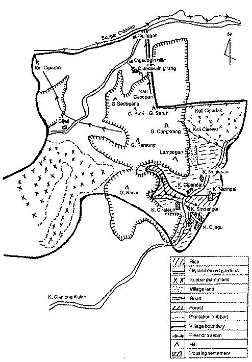
From Jeff Fox, "Aerial Photography and Thematic Maps for Social Forestry," ODI Social Forestry Network Paper no. 2c (London: Overseas Development Institute, May 1986), p. 13.
