


Whether shifting cultivators are "marauders" or "managers" of the forests in which they dwell has long been debated among scholars. But as this controversy rages in academic circles, important decisions about tropical rainforest management are being made by policy-makers. Concern about the fate of tropical rainforests, and about the implications of their loss for the world at large, is growing everywhere. As these concerns are discussed among scientists and policy-makers, shifting cultivation becomes a central issue.
Unfortunately, much of our understanding of shifting cultivation - a practice regularly blamed for tropical deforestation - is based on little or no information. Many policy-makers world-wide consider all shifting cultivators to be villains, "primitive" remnants in otherwise civilized societies, wreaking havoc on valuable forests. This view is also common in Indonesian policy-making settings.
There is an obvious appeal in the "marauder" view for policy-makers, who must seek simple solutions to complex problems. Shifting cultivators, whose actual practices vary widely, are easy to blame when assessing forest destruction. They are most often poor rural dwellers without political or financial strength, unsophisticated and powerless in the wider political world where the timber industry, plantation agriculture and oil and mining concerns play powerful (and well-funded) roles.
In the case of Indonesia, the country's longstanding Transmigration Programme (under which people are resettled from one province to another) also encourages adherence to this view. This programme appeals to policy-makers, for whom it is a tool for addressing the woes of Java and Bali, Indonesia's most densely populated islands. Sparsely populated regions, most likely to depend on shifting cultivation as an economic base, are precisely the areas selected for this programme. This kind of resettlement can intensify the problems of conflicting claims on forested lands.
Certainly Indonesian policy-makers are faced with daunting choices. In effect, lined up against the shifting cultivators (some of whose systems are environmentally damaging) are a variety of legitimate concerns: the foreign exchange revenue from the sale of timber and other natural resources, population pressures and poverty on Java, and concerns about food self-sufficiency. The Indonesian Government, as those of other developing nations, is working to improve the people's standard of living. There are real and significant reasons for utilising Indonesia's national resources (timber, agriculture, land, oil, minerals) to this end.
But some current policies, as implemented, are not sustainable. The natural resources of East Kalimantan are being commercially exploited without sufficient regard for the welfare of the indigenous peoples of the province. Though underutilised, East Kalimantan's renewable resources flourished under indigenous management, while now these resources are being harvested unsustainably, a process which promises to leave local people destitute and the local environment severely impoverished. If the current trends continue, in the long run the value of these resources will be diminished.
This monograph examines shifting cultivation as a potential basis for more sustainable natural resource management in East Kalimantan.3 Although shifting cultivation varies in important ways in differing contexts, it will also become clear that shifting cultivation in some contexts is quite sustainable.4 Indeed, shifting cultivation can provide a model or base on which "modern scientific" agroforestry technologies can profitably build.
The seed from which this study grew was a Man and Biosphere project called "Interactions between People and Forests in East Kalimantan." The policy-oriented goals of this 1979-80 project were to examine shifting cultivation in several contexts, to evaluate the effects of the Indonesian Government's programme to resettle Dayaks (the indigenous people of Borneo) in more accessible areas, and to investigate the potential of participatory rural development. The approach used first identified human actions that had an impact on the forest. Such actions were then examined by tracing their complex links outward (as far as relevant and possible) from the individual action.5 Forest clearing for rice production quickly emerged as the most important local human action affecting the forest in the resettlement village of Long Segar, East Kalimantan. The study of land and forest use, on which this monograph is based, was thus begun.
The understanding of shifting cultivation gained in this original project was then supplemented by increasing involvement in agricultural research in humid tropical rainforests, and observation of the effects of the continual, and often unsuccessful, struggle to encourage conventional permanent agriculture in this context. Shifting cultivation as practised in Long Segar seemed to provide an agroforestry pattern which, if researched and built upon using scientific methods, might provide more fruitful and sustainable results than the conventional agricultural approaches (permanent, monocropped fields).
From a longitudinal, agro-ecosystem perspective, traditional forms of shifting cultivation appear to be more stable, sustainable, equitable, and productive than many other systems. The issue of sustainability is a particularly complex one. Obviously shifting cultivation has shown itself to be sustainable in the past, since large expanses of forest thrived as part of traditional agroforestry systems. In considering the future, the arrival of other interested parties (timber, oil and mining industries, plantations, resettlers, etc.) must be taken into account. A further question relates to whether sustainability should focus on agriculture and the subsistence system alone, or includes maintenance of significant amounts of old growth forest. Though the latter may not be necessary for local human subsistence, it is desirable from a global perspective.
This monograph examines the process of change and development in the system of shifting cultivation practised by the Uma' Jalan Kenyah6 over three decades, tracing them from their homeland in the remote interior of Borneo, through their involvement in a government-sponsored resettlement programme, to their ultimate dispersal and formation into three new daughter communities. These four communities are compared with regard to population, land/forest use, productivity, and land tenure. These analyses shed light on the nature óáf shifting cultivation and its potential as a model for improvements in agroforestry development, and can serve as a stimulus for agriculture and forestry scientists to attempt to improve these systems rather than trying to supplant them. Such improvements, combined with changes in Indonesian forest policy, could contribute to enhanced productivity, as well as to the conservation of significant areas of humid tropical rainforest.
In trying to develop benign policies that benefit people in a sustainable manner, policymakers must cope with a bewildering array of issues (and myths) in making decisions about forest use and shifting cultivation. A few common misconceptions are discussed below.
Belief No. 1:
"Forests are being cut down by shifting cultivators whose numbers are increasing at incredible rates."
It was found that the Uma' Jalan Kenyah are not reproducing at a particularly fast rate. Although much of the 1980 population of Long Segar (the village studied longest) has dispersed to other locations, the total number of people there and in its "daughter villages" grew only slightly between 1980 and 1990. Data from these villages suggest that in-migration rather than high birth rates is the biggest factor in population growth in the area (see section on "Population" in Ch. 3 for further discussion).
Belief No. 2:
"Shifting cultivators are like nomads, continually on the move."
Long Ampung, the homeland of the people studied in this monograph, has been continuously inhabited by Uma' Jalan Kenyah for roughly 100 years. Long Segar, first settled in 1962, remains a village. The process of village fissure has been influenced by access to the outside (education, health care, consumer goods, markets) but also appears to be linked to access to and maintenance of natural resources. At a certain point, people must go too far to reach their fields; disagreements over land arise and some decide to move on. The absence of severely degraded lands around any of these villages (except possibly at the site settled under the Transmigration Programme) suggests that village fissure may serve, among other things, to maintain land quality when population reaches a critical point.
Belief No. 3:
"Shifting cultivation destroys the land, leaving only grasslands in its wake."
Even within the same ethnic group, shifting cultivation varies considerably from place to place. The most sustainable variety occurred in the remote hinterlands (Long Ampung) where almost no old growth forest is cut, and people use their fields in long fallow rotations. The system which appeared to be the second most sustainable type of cultivation was in Tanah Merah, near the city of Samarinda.7 There, various factors (e.g., population pressure on the land; access to markets, inputs and education; awareness of government conservation policies) were pushing people to diversify their system, incorporating small scale tree crop plantations, making smaller ricefields, and having fewer children. Long Segar was an intermediary context, where most people control their family size but continue to cut old growth forest insofar as possible (80% of their fields in 1980, but down to 66% in 1990). Outmigration precluded any significant imbalance between land and population. The Muara Wahau transmigration community was growing most rapidly and clearing the most old growth forest (96% of their fields in 1990). In none of these communities were there extensive areas of grasslands, though such an outcome seems probable in the transmigration location.
Belief No. 4:
"Among shifting cultivators, women are particularly disadvantaged."
The high status of Dayak women has been widely reported in the anthropological literature, and the Uma' Jalan Kenyah are no exception.8 One critical factor, on which their status probably ultimately rests, is the intimate involvement of these women in shifting cultivation. Female involvement in productive activities is generally associated with lower birth rates in all societies. This is an important factor in the comparatively slow population growth found in the study villages.
Belief No. 5:
"Shifting cultivation is an unproductive use of land."
"Shifting cultivation typically develops in situations of land abundance and labour shortage, where the productivity of human labour is more critical than production per unit of land. Average rice production over 28 years in Long Segar was only 1,170 kg/ha, but shifting cultivation is a system which generates a variety of by-products which are normally ignored in assessments of productivity. After clearing for rice production, as the forest returns, different products are planted, encouraged, or simply collected from the different stages of regrowth. These include a wide variety of food crops, animals, fruit trees, medicinal plants, timber, and nontimber forest products for sale or home use (see section on "Agroforestry Productivity" in Ch. 3). People's dependence on these other components of their system is most obvious in years when natural disasters occur. Also, the partially fallow periods serve important environmental functions in maintaining soil fertility and water quality and availability, and in reducing weed, pest and disease problems (Mackie 1986b; Whitmore 1990).
Belief No. 6:
"All we need to do to make this land more profitable is to convert these people to sedentary food-crop farming."
An important finding in this, longitudinal study was the high risk level involved in agricultural pursuits on lands such as these. The stability of any system depending solely on annual food crops appears highly questionable. Droughts, landslides, flooding, large and small pests, and plant and human diseases continually plague farmers' efforts in their ricefields. Shifting cultivators have developed a diversified system which relies on the varying stages of forest regeneration and riverine abundance to enhance the stability of their system by supplementing their necessary but chancy rice production efforts. The Kenyah continue to change and adapt their system, in response to changing external circumstances. The strong cultural value placed on sharing in this culture also serves to reduce the impact of recurrent crop failures on individual families.
Belief No. 7:
"Shifting cultivators are "primitives," resistant to change, who need to be civilised."
Shifting cultivators were found on the contrary to take a very flexible and open approach to change. They have readily adopted new plant varieties, as well as birth control, money, rice milling machines, outboard motors, chainsaws, and wheelbarrows, as these became available. They have extensive stores of indigenous knowledge about their tropical rainforest environment which could serve as a basis for further scientific study.
The equitableness of a system, defined as the degree to which goods and resources are distributed equally among the population, is a major goal in developing an agro-ecosystem, and can also be seen as a goal of "civilisation." Although some differences in rice production per family were found between traditional aristocrats and commoners, goods generally are remarkably equitably distributed among the Kenyah in all four locations.
Belief No. 8:
"Logging, combined with the devastating fires of 1983, have adversely affected agriculture in East Kalimantan."
Although the complexity of intertwining causes and effects precludes a definitive comment on this view, data do suggest that neither logging nor the fires have had a significant long-term effect on rice production in Long Segar. Indeed, rice production appeared to be slightly higher in fields cut from newly logged forest and during the period after the bum. The worst effects of logging and the burn relate to their effects on biodiversity.
Belief No. 9:
"Lands cleared from old growth forest are the most fertile for agricultural use."
It was found that fields cut from old secondary forests in fact produced significantly higher yields than any of the other forest types (old growth, young secondary, and the previous year's ricefield). This finding is also contrary to conventional Uma' Jalan Kenyah wisdom.
Belief No. 10:
"Transmigration improves people's standard of living and transfers superior Javanese agricultural strategies, thus bringing development to Indonesia's Outer Islands."
Although farmers coming from other islands may benefit from transmigration, local cultivators who join the programme do not generally feel they are any better off. They also tend to have more children and cut larger areas of forest each year than the people in their original homes. Transmigrants, rather than teaching their agricultural methods to the local people, were found to adopt shifting cultivation as the only viable system for subsistence. The influx of thousands of families into areas which are unsuitable or marginally suitable for settled agriculture tends to adversely affect the quality of life of the indigenous populations - and ultimately, that of the newcomers as well.
Some of the above beliefs could well apply in other locations. But their inaccuracy among the people and contexts studied here suggests that they should be discarded as viable generalisations. As the following study demonstrates, policies should not be based on such beliefs without first evaluating local conditions.
These brief descriptions of the four study communities provide a context for the subsequent analyses of issues related to forestry and people in East Kalimantan. Environmental information from other studies is included where available.
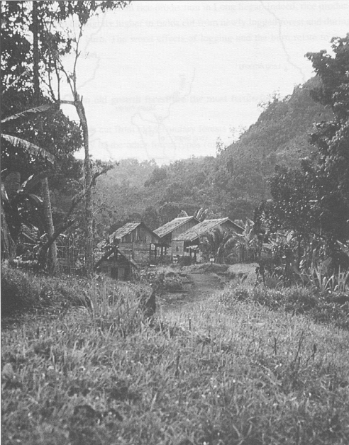
Long Ampung, the remote settlement that is the original home of the Uma' Jalan Kenyah, is situated on the Kayan River in the centre of Borneo. Long Ampung's 1990 population (87 households, with 460 people) was slightly smaller than its 1980 population (69 households, with 486 people) .9
The people are Christians, living a riverine lifestyle with swidden rice cultivation as the economic base. The rice diet is supplemented with produce from small gardens, and wild and semi-wild produce from the surrounding forests. Hunting and fishing provide the major source of protein. Consumer goods and cash are acquired by trekking on foot to Malaysia (where the standard of living and wages are considerably higher), and carrying the booty home in backpacks.
The village of Long Ampung
In 1980, the Government built an airstrip in Long Ampung. Flights are scheduled twice a week by Asahi, a subsidised commercial airline, which can carry 700 kg. (8-15 passengers and their baggage). Many obvious-changes have taken place: solar panels have been flown in to power the airline's radios; there are several small stores and a rice hulling machine; people have access to birth control and some other medications; one occasionally hears the sound of a chainsaw or outboard motor; and backpacking tourists regularly visit the community. The dominant housing style in 1980 was the longhouse; in 1991 there remained only one ten door longhouse and two mini-longhouses housing 2-3 families, with the rest of the villagers living in single family dwellings. Formal leadership has shifted from an older aristocrat to a younger literate man.
Yet many things remain the same. The cost of fuel is so high in this remote village that the chainsaws, outboard motors, and rice hulling machines are often idle. Transport of cargo to and from Samarinda, though subsidised by the government, remains expensive by local standards, making consumer goods exorbitant in a community where there is almost no opportunity for wage labour. Sugar, for example, costs twice as much in Long Ampung as in Long Segar. Kenyah norms of hospitality and interpersonal relations often prevent them from reaping the economic benefits which could come from tourism. For example, the Kenyah deem it impolite to discuss payments when guests arrive, leading western guests to assume they are receiving hospitality gratis.
The absence of thievery and other crimes is noteworthy, as is the capacity of village members to mobilise and work together.10 Long Ampung is in many ways typical of remote hinterland settlements, practising a traditional form of shifting cultivation in humid tropical rainforests.
Long Segar is a daughter village of Long Ampung, two days and two nights up the Mahakam and Telen Rivers from the provincial capital of Samarinda (Figure 1, p.9). The population of 551 people in 1990 is roughly half its 1980 size of 1,052.11
Interestingly, Long Segar is more isolated now than it was in 1980. At that time, was concluding its participation in a formal resettlement project which had include periodic visits by officials, as well as "droppings" of building materials, agricultural implements and other goods and services. MAF (the Christian Mission Aviation Fe lowship) had an airstrip, and its small planes landed irregularly in Long Segar. The was also an active German aid project (with plane and radio), with sites upriver ai downriver from Long Segar.
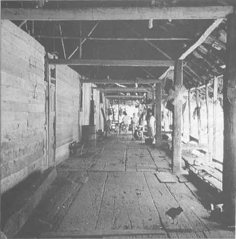
The verandah of the last remaining longhouse in Long Ampung
Georgia Pacific, the American-based timber compai which held the concession in which Long Segar is located, also had its own plan( boats, and other avenues for external communication.
By 1991, the Resettlement Project was long gone, the Government had prohibit MAF planes from landing in Long Segar because Long Segar's airstrip did not cc form to the new regulations, TAD had phased out its operations, and Georgia Paci had been replaced by P.T. Kiani Lestari, an Indonesian timber company for whi outside communications were less of a priority.
Internal politics had changed significantly as well. In 1980, the village had a strong leader with vision. Religious and other differences within the community were submerged. In 1991, leadership was split between the official headman, a teacher and the son of the previous headman. A distant field cluster looked like it might become a separate community. This field site (along the Pantun River, see Figure 3, Ch. 2) was being encouraged by extension agents from the Muara Wahau Transmigration site, aided by tree crop inputs from the timber company. The Catholic community in Long Segar might as well have been a separate village, with their priest (from Timor) serving as an effective link to the outside world.
The economic life of Long Segar has important similarities with that of Long Ampung. Swidden rice cultivation forms the core, supplemented by small-scale gardening both in the village, and in the various stages of forest regrowth. Hunting and fishing remain important. But there are also some significant differences. Marketing of rice, for instance, is part of the Long Segar economic strategy (with easy access to consumer goods). There are regular river boats providing accessible, inexpensive transportation both up and down the Telen River. It is therefore no longer necessary for Long Segar's men to make long treks to Malaysia, though periodic shorter-term wage labour away from the village is common.
Medical and educational opportunities are better in Long Segar, and access to rice hullers, outboard motors, and chainsaws has been commonplace since the mid-1970s, aided by low fuel prices. A recent innovation has been a form of wheelbarrow (gerobeg), which has been used since 1984 for transporting rice home from fields. A person can carry 16 tins of rice on a gerobeg, as opposed to two or three on his/her back. This has resulted in considerably improved paths to ricefields, which has in turn led to more interest in using logged lands with roads built by logging companies. Kenyah use of the logged area (with roads) near the Pantun River began in 1985, and fields there parallel the road, not the river, as was previously the case.
Since the mid-1980s, there has been an exodus from Long Segar to three other areas: Muara Wahau, Tanah Merah and Karang Umus12. Between 1980 and 1991 there also appeared to be a significant increase in petty crime in Long Segar. Minor thefts are rampant. A comparison with the incidence of crime in Long Ampung is an indication of the sometimes conflicting "benefits" of modernity.
Tanah Merah is a community of 43 Protestant (KINGMI13) households with a population of 226. It is located on the site of a former ITCI base camp14 about two hours up the Jembayan River from Samarinda by motor-driven canoe (Figure 1, p.9). Although officially part of a larger village (Sentuk) just upstream and across the river, Tanah Merah is separate and autonomous for most purposes.
The economic base remains the same in Tanah Merah as in the previous two communities, with people depending most fundamentally on shifting rice cultivation, supplemented by hunting and fishing. However, local interest in plantation crops is high, and some families are successfully marketing crops like bananas for sale in Samarinda and Balikpapan. With Samarinda two to three hours away, many of life's needs can be met more easily than in Long Segar. A side effect of this accessibility is that social problems that are unheard of in Long Ampung and were rare in Long Segar in 1980 have become commonplace. Young men steal, young women enter prostitution.
Although 21% of the families came from other Uma' Jalan Kenyah communities (Sentosa and Gemar Baru), Tanah Merah's leadership is entirely from Long Segar.
Three men appear to cooperate well in leading the community, one of whom is an innovative informal leader who links the community to the outside world. The people of Tanah Merah represent the many villagers who are drawn ever-nearer to the city, in search of better medicine, better education for their children, and ready access to markets and other sources of money.
Muara Wahau is the capital of the kecamatan (subdistrict) in which Long Segar is located. Some 6-8 hours by riverboat up the Telen River (30 km) from Long Segar, Muara Wahau has been the site since 1986 of a major Transmigration Project covering 37,000 ha. In 1990 there were 164 Uma' Jalan Kenyah residing in the Transmigration location. Their average family size has hovered around six since their arrival in 1986.
A road has been built linking Muara Wahau to the coast. Transmigrants from six provinces live in the transmigration site: East, Central and West Java, Nusa Tenggara Timur (NTT, Christian), Nusa Tenggara Barat (NTB, Muslim), and several kinds of Dayaks from East Kalimantan.
There has been an informal division of labour by ethnic group. People from NTT plant cashews and raise chickens. The Javanese likewise show an interest in chickens, but grow a mixture of fruits (particularly coconuts and citrus). Dayaks typically plant pineapples and sugarcane, supplemented by small-scale, semi-commercial fishing. The people from NTB are most familiar with and interested in (yet, ironically, have had least access to) cattle.
In 1986, at the invitation of the camat (head of the kecamatan), a small group of nine families from Long Segar moved to Muara Wahau and formed village Unit 3.15 The next year 15 more families moved there, a few settling in Unit 4 as well.
Although during their first year, these local transmigrants grew rice on the fields assigned to them by the Transmigration officials, the following year, they all (without exception) cleared additional forest for their rice crop. Despite considerable effort on the part of Transmigration officials (including hiring at least two Kenyah men to work with them) to persuade them to adopt the sedentary pattern prescribed for transmigrants, they continue to farm much as they did in Long Segar. It is reported that during the past three years, more than half of the other transmigrants have joined the Kenyah in their practice of clearing forest to plant food crops. The Kenyah also appear to be getting more actively involved in commerce - something they traditionally view with distaste.
A brother of an old Long Segar headman leads the Uma' Jalan who have settled in Tanah Merah, while a young, high school educated Uma' Jalan man from Long Segar has an official position as an assistant to the camat. Being part of a Transmigration Project reduces the autonomy enjoyed by leaders in the other Uma' Jalan villages, and Muara Wahau's Kenyah settlers exhibit a sense of dependence on government help and guidance which was not observed in the other settlements.
The basis for this monograph is a body of land use history data gathered in 1979-80, covering the period from initial settlement in 1962 to 1979, augmented by comparable data covering the intervening years from 1980 to 1990. Twenty-eight years of forest clearing and land use are covered.16
Beginning in September 1979, participant observation and a number of quantitative studies were carried out for ten months in Long Segar and one month in Long Ampung. The focus of the study is a series of land use history interviews with all households in Long Segar. Forest type, amount of land cleared for rice cultivation each year and agricultural problems and production were recorded for the period between initial settlement (as early as 1962) and 1979.
In March and April 1991, this earlier study was replicated and extended through 1991.17 Again, every household in Long Segar was interviewed, this time concerning the period from 1980 to 1990. During the period between 1980 and 1985, almost half of Long Segar's inhabitants moved away. However, knowing the number of families in the new locations, it was possible to make reasonable estimates of how many would have been making fields in Long Segar even for those years. The more complete data on people who remained was used as a sample and extended to those who moved. Although theoretically there could be some critically important difference in land use between those who stayed and those who moved, the similarities that remain among villages make this seem unlikely.
In late March 1991, this study was replicated in Tanah Merah, near Samarinda, where family land use histories from time of settlement were collected. Although there were 43 families residing in Tanah Merah, this analysis was confined to the 30 which were from Long Segar (156 individuals).
In Muara Wahau, all the settlers from Long Segar (27 families, 164 individuals) in Units 3 and 4 were interviewed concerning their land use since settlement in 1986. Data were also collected on the dynamics involved in people's decisions to move from Long Ampung and, more recently, from Long Segar.
In Long Ampung, land use data were collected from a random sample of 25 families (29% of the households). This sample was interviewed on land and forest use over periods of time ranging from two to 17 years, including a total of 189 ricefields. Most Long Ampung analyses derive from the data covering the period 1985 to 1990, as these were the most reliable.
These analyses seek to identify important factors bearing on the indigenous agroforestry management system, and examine them within a historical perspective.18
That shifting cultivators move periodically is widely known, but the reasons are less clear. In this monograph, one goal is to document the process and factors leading to village fission. Jessup (1981) has convincingly argued that ecological factors such as grassland invasion and soil depletion are not sufficient to explain the moves of shifting cultivators. A better understanding of the factors that encourage these cultivators to move away from their villages and open new areas of old growth forest is necessary for the development of policies that protect both the forests and the people who inhabit them.
Uma' Jalan Creation MythUma' Jalan means "Longhouse of the tarsier." One story goes that during the time of Bilung Njau, the first Uma' Jalan, the people were cooking together near the river. A tarsier (Tarsius bancanus) climbed into the cooking pot, and although the people put water into the pot, the tarsier remained, so they called themselves the people of the tarsier. According to another story, Bilung Njau was looking for a place to settle, and found a likely place, where a tarsier was sitting in the branch of a tree. He selected the spot, and thereafter referred to himself and his people as Uma' Jalan. Ever since, if a tarsier is spotted in an area being considered for making a ricefield, the site is rejected. According to a respected older man in Long Ampung, before Bilung Njau there were only spirits. This man gave his own genealogy leading back to Bilung Njau: his mother was Uding Anye'; her father was Anye' Njau; Anye's mother was Sinan Ngau; and Sinan's father was Pengau Bilung, son of the original Bilung Njau.19 |
Jessup (1991) puts the Kenyah move from the Iwan River area at about 150 years ago. The Uma' Jalan were apparently comparatively stationary until mid-century ; at that point a series of conflicts within the village, combined with enticements from the outside, such as education, health care, and consumer goods, led to successive waves of outmigration. The outmigrants typically left in groups, forming new villages in more accessible areas (Figure 2). As in Jessup (1981), it was found that people were not moving simply because of population pressure or environmental factors. A variety of internal conflicts regarding religion, politics, social change and land affected the decision to move.
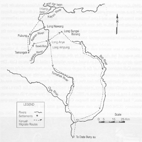
Figure 2
Kenyah migrations
to and from Long Ampung (Cartography by Robert Abrams).
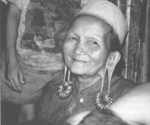
An Uma' Jalan woman in Long Ampung
In 1940, George Fiske of the American Christian Missionary Alliance made the first flight by a missionary into the Apo Kayan (the headwaters of the Kayan River) where Long Ampung and Long Sungai Barang are located. But Christian influences had already been felt in the area for some time, brought home by Kenyah travellers.21 Christianity's early impact on Long Ampung outmigration was felt when the first Christian longhouse moved away en masse in 1948.
In addition, a new animist cult was founded in Long Ampung in 1942. A villager by the name of Juk Apui was visited by the spirit of Bungan Malan. (a traditional female deity), and persuaded to found a new religion, called the Bungan Cult. The Bungan Cult retained much of the Kenyah animist religion, but reduced the number of taboos (and consequent fines) governing life. It was widely accepted in Long Ampung and elsewhere. The fact that Juk Apui was a Panyen (commoner) was of particular significance, since leadership was traditionally reserved for Paren (aristocrats). Long Segar's headman in 1980, the only Kenyah headman with commoner status,22 had been active in the Bungan Cult prior to his conversion to Protestant Christianity (KINGMI). This cult remained strong until the 1960s.
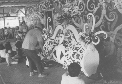
Decorating the coffin of an aristocratic woman
Large numbers of Indonesian soldiers came to the Apo Kayan in 1963, in response to political difficulties between Indonesia and Malaysia (Konfrontasi), and pressure to become Christian increased (cf. Atkinson 1988, on the Indonesian Government's policies on animist religions) .23 In 1964, acting in concert with an Uma' Jalan Christian convert, the soldiers offered the villagers the "choice" between conversion (to Christianity or Islam) and death. The Uma' Jalan predictably chose Christianity over Islam because of the importance of pork in their diet, but this inauspicious beginning does not seem to have adversely affected their religious devotion. In 1980, Long Ampung had three distinct Christian congregations (KINGMI, GPIB and Katolik24) which by 1991 had each built its own church building. Although people no longer worship Bungan Malan, the spirit world remains a potent force for most Uma' Jalan Kenyah. Many Uma' Jalan see strong parallels between prayers to the Christian God and the earlier prayers to Bungan Malan.
In 1962, a group of Communists came to Long Ampung, seeking Dayak fighters. They tied up the community leaders, threatening to leave them to die in the sun, if the young men did not join them in their fight. After the leaders had remained tied up for three days, 100 young men agreed to fight with the Communists. Interviewees stressed their lack of ideological interest in Communism, and their personal concern to save their community leaders. Many people have thought, erroneously, that the traditional Dayak way of life was communist because of their shared residence in a longhouse.
In 1963, two of the most influential Uma' Jalan leaders died (one of them killed in the confrontation with Malaysia), creating a leadership vacuum. Guests at one of the funerals were estimated at 1,000. This same year the rice crop was abysmal, and almost no one grew enough rice for subsistence needs. The rice requirements for these important funerals must have sorely strained the resources of the community.
Around this time, a controversy had arisen in Long Ampung concerning the role of the Paren (aristocrats). Among the Uma' Jalan Kenyah, aristocrats had conventional leadership responsibilities and were owed tribute from Panyen (commoners). However, the democratic principles being discussed and adopted in other parts of Indonesia were beginning to make their way to Long Ampung. The commoner with a gift for speaking who was to become Long Segar's headman in 1980 began during this period to challenge the rule of the aristocracy in Long Ampung. He argued with the Paren that human beings were equal in Christianity and under Indonesian law, and that the traditional distinctions between Paren and Panyen should be discarded. Details of this controversy remain obscure, but that it was acrimonious is exceedingly clear from the descriptions given by others.
Land scarcity appears to be an issue in Kenyah decisions to move, though Kenyah themselves unanimously reject this idea. The desire to acquire land or being greedy about land is so strongly disapproved that it can be a fineable offence. However, Long Ampung has supported a considerably larger population in the past than it does today.
In 1965, there were between 9 and 12 longhouses, the longest of which had 86 apartments; Hadikusumah and Sakuntaladewi (1991) report that the population of
Long Ampung at that time was around 3,000. By 1970, Whittier (1973) reported the population to be 895. The 1980 population was around 500 (Colfer 1985a,ó), with only five longhouses left. People remember having had to walk long distances to find land suitable for making their swiddens, and a few acknowledge leaving Long Ampung in search of old growth forest. The 1990 Long Ampung census lists a population on 460, and by 1991 the number of longhouses had dwindled to one.
There were other indications that land scarcity might be an underlying issue. In 1957, the people of the neighbouring Lepo' Tau Kenyah village ostensibly moved the posts marking their long-standing border with Long Ampung, and made a ricefield in land claimed by Long Ampung. This resulted in a heated meeting between village elders and the restoration of the original border .26 But the incident reflects a broader, longstanding tension over land rights between these closely connected Kenyah groups.
There were also intra-village disputes. In the early 1960s, for instance, two longhouses had a disagreement over ownership of a honey tree. Longhouses typically own the path to their ricefield clusters, but in this case two longhouses shared the beginning of the path, which split at some distance from the village.
When bees made honey in a tree that grew along the shared path, the question of who owned the tree could not be resolved, and one of the longhouses moved to another village. The yearly community prayers (whether to the Christian God or, previously, to Bungan) which precede the search for new forest areas to cut for ricefields similarly suggest that land scarcity is aft important issue. The people typically make the following requests:
"Help us not to argue about land;"
"Help us find permanent boundaries;"
"Help us make good choices, splitting areas wanted by more than one family;"
"Improve the land so the rice will grow well;"
They conclude by saying they will thank God (or Bungan) after the harvest.
For several generations, the remoteness of the area has required that the men make regular trips out (tai selai, or circular migration, Colfer 1985a) to get various consumer goods, most fundamentally salt. These trips often involve crossing the border into Malaysia 27 The Kenyah themselves stress the draw of "modem" life in their decisions to move from the Apo Kayan. Education, health care, and consumer goods top their list of reasons for leaving. Access to money (hardly used in Long Ampung at the time of the first visit in 1980) through marketing excess produce and working for wages was an additional enticement. In 1967, the people of Long Segar began engaging in logging using a method called banjir kap. This method involves cutting down trees near the river, then waiting for the river to flood to float out the logs (Kartawinata et al 1989). For a period in the mid-1960s this was a very lucrative activity in East Kalimantan (before its banning on environmental grounds in 1971). Such economic successes added to the draw of life in more accessible areas.
From the local level, government policies toward people living in remote areas also appeared to vacillate. On the one hand, there were policies favoring "resettlement" of people residing in Indonesian hinterlands like Long Ampung to more accessible areas. On the other hand, though, the government has been concerned with maintaining an Indonesian population along its borders, such that in the 1950s people who wanted to leave were prohibited from doing so." By the 1970s there was an overt policy to move people out, for example with the establishment of Long Segar as a resettlement village in 1972. The policy of the 1980s was to try to keep people in the Apo Kayan, by means of enticements like improved educational and medical facilities and better access to consumer goods. The airstrip and commercial airliner in Long Ampung are part of this strategy.
The focus of this monograph is on Long Segar, for which there is a record of forest clearing since 1962. But sorting out fact from fancy has been quite difficult for its early history. The land use histories document a very slow growth from one couple29 in 1962 to 20 in 1969, doubling in 1970, and reaching 100 families by the time Long Segar was declared a Resettlement Project in 1972. But there is great disparity in people's perceptions of who the leaders were in these moves.
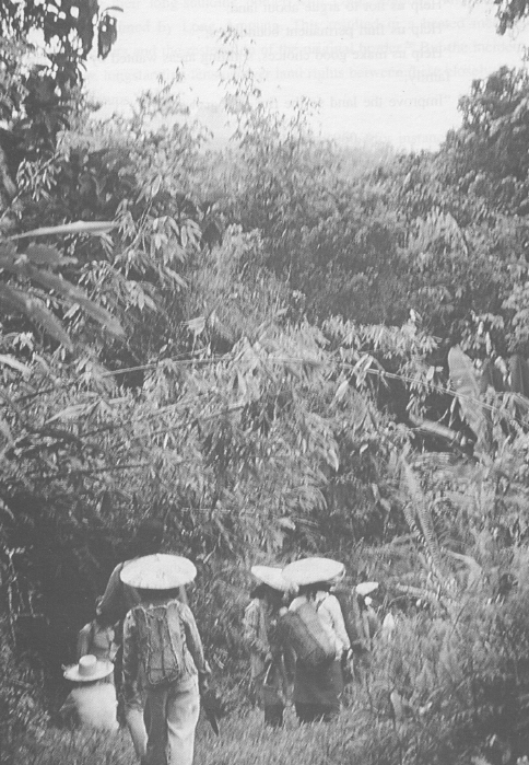
Clearing the path
from Long Ampung
to Long Nawang
In 1962, a group of about 30 people went to Samarinda in search of a new home, closer to trading centers. There, they heard about Long Segar, where only a few Kutai and Bahau people were living. When they went to see it, they liked its old growth forest with abundant pigs and rattan, a river with enough fish, ironwood (Eusideroxylon zwageri) for housebuilding and other construction needs, land with a nice view. Many of them repeated the one month roundtrip to Long Ampung on foot and in canoe to bring others with them.
In 1965, 22 more people left for Data Bunyau, en route to Long Segar. Soon after this a group of 75 people from Long Ampung, led by the commoner headman mentioned above (section on Politics and Social Change), headed for the newly established community in Long Segar. There, this man established himself as the leader of the community, retaining his position even after a number of aristocratic families arrived. Long Segar aristocrats maintain that he was able to lead because none of the local aristocrats (of sufficient age and the male gender) were "clever at speaking." His success is evident in the illegality of mentioning the Paren-Panyen distinction (a fineable offense). The aristocrats lost their traditional, status-defining rights (e.g., exclusive use of particular artistic symbols, economic tribute, unquestioned authority in certain issues, etc.), though people remain aware of the distinction. His younger brother has become headman of the Kenyah community in the Muara Wahau Transmigration Area, and other commoners are now active in Long Segar leadership, suggesting that this man's democratic philosophy may have made some lasting inroads.
In 1968 two more longhouses left Long Ampung, and more people came to Long Segar. In 1969, about 400 people from two other longhouses, including Long Segar's first Catholics, began a one and a half year trip with Long Segar as their ultimate destination, stopping in Sungai Mau for one year making ricefields.
Thus the decision to leave the Apo Kayan was made repeatedly by groups of people of differing size. Reasons ranged from religion to politics to access to land to other more personal reasons. An adventurous spirit, the quest for leadership opportunities, a desire to escape some unpleasant personal situation, the draw of an easier life: all of these factors could influence people's decision-making, affecting different individuals differently. Overall, the sum of these decisions to move resulted in a reduction in the intensity of land and forest use in the Apo Kayan and an increase in the clearing of old growth forest in areas closer to the city.
3 This study does not examine the sustainability of plantation agriculture in this context, though there is some evidence that such agroforestry systems work. One main reason for this exclusion is the fact that plantation agroforestry is not as compatible with the maintenance of large areas of natural forest as are the forms of shifting cultivation discussed here. The maintenance of old growth, humid tropical rainforest is an important consideration in the context of this study.
4 Conway's (1985; 1987) convenient system of characterizing agroecosystems by their productivity, stability, sustainability, and equitability is used periodically throughout the text.
5 This approach was later refined as "progressive contextualization," Vayda 1983; see also Vayda et al 1980.
6 The Uma' Jalan are a sub-group of the Kenyah Dayaks, shifting cultivators of East Kalimantan, and the primary subjects of this study.
7 This finding is interesting when compared with earlier findings from the UN Man and Biosphere project, "Interactions Between People and Forests in East Kalimantan" (e.g., Kartawinata and Vayda 1981; Vayda and Sahur 1985). These studies of Bugis pepperfarmers (recent immigrants from Sulawesi) were done quite near to Tanah Merah and described a shifting cultivation system in which the soil was cropped until it was depleted and then abandoned. Perhaps more important than proximity to the city, as it initially appeared, is experience in comparable environments. It also may be true that Kenyah Dayaks consider all of East Kalimantan to be their home, whereas the Bugis immigrants certainly do not.
8 See Colfer (1981a&b,1982, 1983, 1985a&b, and 1991a) for documentation of this high status.
9 Figures based on a de facto census by Coffer.
10 During a 4-day visit in 1991, three all-village activities were planned and smoothly executed: repair of part of the path from Long Ampung to Long Nawang; creation of a large "welcome" sign on the path from the airstrip to the village as required by the government; and a major funeral of an aristocratic woman.
11 The 1990 figure is from the official government village census; the 1980 figure is from Colfer's de facto census carried out during the study. Colfer's 1980 de jure census counted 1,139 people in Long Segar and 508 in Long Ampung.
12 Tanah Merah and Muara Wahau are discussed below, but Karang Umus is not included in this monograph. Not long after the Big Fire of 1983, some 20 families moved there (near Samarinda), where they began to focus their efforts on pepper production. In the mid-1980's the price of pepper went up to Rp 12,000/kg (about $12.00/kg at the 1986 exchange rate); but it has now fallen to Rp. 1,400/kg ($0.72), with disheartening effects on those Uma' Jalan who moved to Karang Umus. Inoue and Lahjie discuss this community as part of a comparative study in East Kalimantan (1990).
13 KINGMI is an Indonesian acronym for Kemah Injil Gereja Masehi Indonesia (Bible Camp of the Christian Church of Indonesia). It was founded by the American Christian Missionary Alliance, a fundamentalist, evangelical Protestant group.
14 ITCI is the Indonesian acronym for what was formerly Weyerhauser Timber Company. Weyerhauser left Kalimantan in 1986, and the concession was taken over by Indonesians.
15 In Transmigration Projects, villages are typically called "unit" or "blok" People who are accepted into Transmigration projects from nearby areas are called Tran Lokal (Local transmigrants).
16 These initial data were collected in 1979-80 under the UN Man and Biosphere Programme, as part of the project entitled "Interactions Between People and Forests in East Kalimantan." The subsequent study was conducted as part of a training programme in Advanced Rapid Rural Appraisal, funded by the UN Food and Agriculture Organization's Community Forestry Programme, between February 1991 and February 1992.
17 A translation of the form used in the 1991 component of the study can be found in Appendix A.
18 Several simple statistical procedures were used to support the overall assessment of the field data, following a stepwise procedure. First, response variables (e.g. yield per hectare, or total rice available per family) were examined in relation to relevant 'effect' variables (e.g. forest type in which fields were made) by using a Chi Square contingency table. For continuous variables, such as kilograms per hectare, this was followed by a comparison of the means among the different levels of an 'effect' variable, using either a simple ANOVA or appropriate t-test. In some cases where the response variable was not normally distributed, a normalization procedure, or a rank test, was used. Following this, differences were examined among various sub-sets of the data (e.g. yield per ha on various field types in non-drought years).
19 Massing (1980) measured 10% of the fields in Long Segar, and found 2 belek per hectare to provide a fairly accurate estimate. Azier (1980) measured five fields in the area, with the same result. Kecamatan records use the same conversion factor. Massing also found three belek to be the appropriate conversion factor for other communities in the area which typically preferred secondary forest, and several Kenyah villagers considered three belek to be intuitively appropriate.
