


Bhutan is a mountainous country, with an estimated area of about 46 500 km2. It is bounded by the Tibetan plateau of China in the north, India in the east and south and Sikkim (now part of India) in the west. The country is normally classified into three geographical zones: the foothills, a 20 km-wide strip in the south, rising to an altitude of 1 500 m; the middle mountains, rising gradually to an altitude of 5 000 m; and the high mountains, with altitudes reaching over 7 500 m (Bhutan's two highest mountains are Jhumo Lhari at 7 541 m and Kula Kangri at 7 314 m). Flat land is limited to a few relatively broad river valleys in the mid country and a small section just below the foothills.
The population of Bhutan was estimated to be almost 600 000 in 1993, and was 90 percent rural. Estimated population growth rate has remained at about 2 percent since the 1950s, and life expectancy is 45.8 years for men and 49.1 for women.
As is the case in neighbouring Himalayan ranges, the land mass of Bhutan has fragile geology and immature soils. In the foothills, a combination of factors such as steep slope gradient and loosely consolidated bedrock tend to promote severe surface erosion in spite of thick vegetative cover. In the high mountains, rocks are resistant to weathering, and because of low rainfall and temperature, chemical weathering is also slow. Hence the soil formation is slow, leading to shallow soil depth with a high percentage of rockiness and stoniness. In the middle mountains, granites and limestones are highly weathered.
The series of mountains in Bhutan are dissected by fast moving rivers that flow from north to south through deep and narrow gorges and steep-sided ravines. These rivers are fed by perennial snows and the summer monsoon or both. The country is drained by four major river systems - the Torsa, the Wang Chu, the Sankosh and the Manas (see Map 2).
Owing to the wide variations in the physical features within short vertical as well as horizontal distances, Bhutan has great diversity in climate compared to other regions of similar size, ranging from hot and humid subtropical in the south to perpetual ice and snow in the high Himalayas. Each valley has unique climatic characteristics resulting from differences in altitude, rainfall, and exposure to sunlight and wind, but the predominant climatic feature is the southwest monsoon. Overall, 60 - 90 percent of the precipitation falls between mid-June and September. Precipitation decreases as altitude increases and as one moves from west to east. The foothills on an average receive more than 2 500 mm of precipitation annually, whereas the middle mountain valleys receive between 500 and 1 000 mm and the high mountains rarely more than 500 mm1.
Mean temperature logically follows altitude, ranging from the subtropical belt at about 15° to 30° C, to middle altitudes of around 1 500 m where the climate becomes cool and misty much of the year, to the high mountains at 3 500 m and above, where the climate becomes increasingly severe with limited precipitation, short cool summers and long cold winters2.
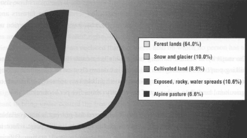
Sixty-four percent of the land area in Bhutan is covered by trees, 6.6 percent by alpine pasture/meadows and shrubs, 8.8 percent by agriculture, 10 percent by snow and glacier and 10.6 percent by exposed rock, grasslands, water, etc. (see Fig. 1). Five distinct vegetation zones can be delineated according to altitude.
1 ) Below 1 000 m: Tropical zone, with forests of Terminalia, Largerstroemia and Shorea spp. Much of this land is now being used for cultivation.
2) 1 000 and 2 000 m: Subtropical zone, with extensive forests of Schima, Castonopsis and Lithocarpus spp. Some of these areas are now being used extensively for shifting cultivation.
3) 2 000 to 3 000 m: Temperate zone, forests of Quercus spp. (oak) and pines. Some of these areas are cleared for grazing and the remaining forests are also used extensively for grazing.
4) 3 000 to 4 000 m: Subalpine zone, forests characterized by Tsuga spp. and Abies with extensive areas of Rhododendron. In the drier areas Juniperous spp. are common. Some of these areas are overgrazed and this is seriously affecting forest regeneration.
5) Above 4 000 m: Alpine zone, characterized by alpine grasslands and wet meadows above the tree line.
Farming systems in Bhutan can be classified into three subsystems: pastoral-transhumance system; subsistence-level crop and animal husbandry; and early commercial farming. The present cropping calendar in valley cultivation proceeds according to traditional beliefs and experience, and has remained relatively unchanged for the past 20 years3.
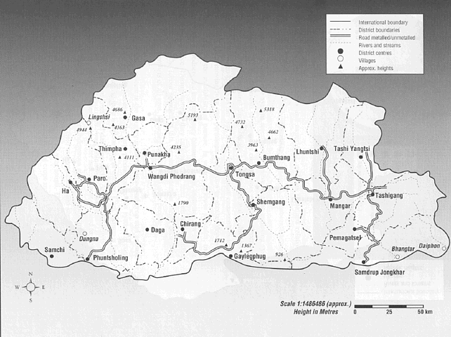
Source: Management Division Thimpha, Mapping Section
International boundary has been supplied by Survey of Bhutan,
vide letter no. P/Maps/611 dated 4th July 1987.
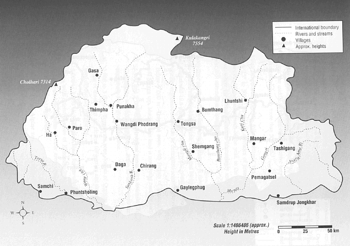
Source: Management Division Thimpha, Mapping Section
International boundary has been supplied by Survey of Bhutan, vide letter no. P/Maps/611 dated 4th July 1987.
The pastoral-transhumance system resembles primitive hunting-gathering systems (Harwood, 1979). It consists of migratory communities primarily dependent on cattle grazing and is prevalent throughout the northern range and at altitudes of 2 800 - 4 500 m, often known as the "yak zone." Transhumant communities lead a semi-nomadic life, moving from one permanent habitation to another depending on the season and the availability of pasture. In winter, at lower altitudes, they trade livestock products and buy necessary consumer items, including low altitude food crops like rice. During summer they cultivate their land with barley, millet and buckwheat. The labour required in this farming system is varied enough to employ family members of all ages, including children and older people.
The majority farming system in the country is subsistence-level crop and animal husbandry. More than 90 percent of the farm production in this system is consumed directly on the farm and there is little selling or trading. Cash income is limited to seasonal marketing of fruits and dairy products. Agricultural inputs and improved seeds are rarely purchased, but leaf litter and compost are used to replenish soil fertility. Tools and equipment are indigenous and there is little mechanization. Households grow a wide variety of field and tree crops and keep an average of five to six head of cattle, producing food all year round. This system provides continuous employment for unskilled labour to tend crops and livestock.
In the southern foothill belt of the country, a small but encouraging amount of commercial farming has begun to emerge during the past 20 years. Here, some farmers are marketing their surplus production. Increased productivity has been achieved by introducing cash crops such as potatoes, chilies, cardamoms, oranges, apples and vegetables. In addition, modern inputs such as improved seeds and fertilizers are being introduced. Development efforts over the last 20 years have contributed to better irrigation facilities and extension services to the farmers and improvements in farm machinery, progressive mechanization, and the adoption of conservation practices.
The majority of settled farming households keep cattle for draught power and milking purposes. Manure from the cattle is extensively used as a fertilizer in crop production. Fewer cattle are kept in the south (about two animals per hectare of agricultural land) than in the rest of the country (about five per hectare)4.
While exact information on the extent of land used for grazing is not available, grazing land overlaps with forest land in all the districts, to the point where in some districts the predominant use of forest land is for livestock grazing. Official records estimate that approximately 10-12 percent (450 - 550 000 ha) of the total land area in Bhutan is presently under seasonal grazing. This grazing land is mainly located in the western region, while the eastern and southern regions have significantly less. Grazing land divides into the four vegetation zones: subtropical, temperate, subalpine and alpine5.
The forest resource in Ehutan is unique in the Himalayan range clue to its enormous variety, changing with altitude over a relatively short distance from subtropical forest through temperate broad-leaved and coniferous woodland to high alpine meadow and scrubs. The country is blessed with high grade forests, which represent its major renewable natural resource. Remote sensing data indicate that as much as 64 percent of Bhutan's land area is forested6.
Owing to the low population density, the forests in Bhutan are in much better condition than those found in neighbouring Himalayan countries. Ninety-four percent of the land under forest is well stocked, 0.5 percent is covered by plantation and only 5.5 percent is degraded. Most of the degraded forest is located in the southern region7. It has been estimated that the present annual harvest of 200 000 cubic m is 70 times lower than what could be harvested annually.
The importance of forest management for sustainable use of forest resources has long been recognized by the Royal Government of Bhutan, and protection and management of forests has always remained a high priority in its development policies. To this end, a Forest Directorate was established early on in 1959. The present Department of Forests was organized in 1967 and it was one of the first government departments. All forest activities other than social forestry and forest fire control are under central administration. An integrated forest management and conservation project has been planned for a period of four years. It is expected that this project will be instrumental in assisting the Department of Forests to strengthen different aspects of forest management such as management planning, silviculture, protection and afforestation, watershed management, social forestry and the development of human resources.
The adoption of the Bhutan Forest Act in 1969 consolidated several previous policies and laws relating to forest rights, the transit of forest products, and forest royalties. A provision in the act declared that any forest land on which no person has a permanent, heritable and transferable right was a Government Forest Reserve, bringing almost all forest land under the control of the government. The act also stated that the government held rights on forest resources on private land. By assigning authority to enforce the rules to the Department of Forests, this was meant to bring under control the free grazing and uncontrolled utilization of forest resources practised by local communities. Yet almost all forest that is accessible to livestock is grazed, and shifting cultivation inside Government Forest Reserves, though banned by law, is widespread.
It soon became apparent that modifications were needed, and thus the Forest Policy Act of 1974 clearly stated the rights and privileges of the local communities. This act permitted private individuals to take dry fuelwood, including dead trees, from forest land upon presentation of a permit. The permits were free but were required mainly to control entry into the forests. A provision allowed for individuals to fell trees for purposes of personal construction, though they first had to obtain clearance from the Department of Forests and pay nominal royalties. Commercial utilization of forest resources was permitted in approved areas against the payment of royalties and a contractor licence fee.
Two major changes were introduced in 1979: the government virtually nationalized all commercial logging operations, and movement of timber or logs by night was banned to control illicit felling and retrieval of timber. The government also restricted the export of logs and sawn timber in an effort to encourage more export earnings by locally processing forest produce.
Community and private forests. The Forest and Nature Conservation Act of 1993 introduced the possibility of practising community forestry and private forestry, and it framed rules relating to this. According to the Community Forest Rules, any area of the Government Reserved Forest that is suitable for management by a local community can be designated as a "community forest area." All households traditionally using a particular forest land unit can constitute a user group. A community forest management plan is prepared by the district forestry extension agents involving the block headman (Gup). Seeds and seedlings and other extension services are provided by the government free of cost. The government does not levy any royalty for use of forest produce by the members of the user group. The group can sell forest products in excess of local requirements, but the proceeds of these sales must be put in a community account for use in implementing the management plan, protecting the forest and for other community purposes.
The Private Forest Rules allow any person to take forest produce from his own registered private land without a permit or royalties, provided that the tree was planted (or sprouted naturally) on the land no earlier than 1979. Private Forest can be established in dry land (kamshing), rotation land (pangshing - cultivated once every four to five years), shifting cultivation land (tsheri) and land adjacent to homestead provided it is registered and does not exceed 25 acres.
Three types of cultivation can be identified among Bhutan's subsistence farmers: valley cultivation, terrace cultivation and shifting cultivation (Negi, 1983). Valley cultivation, in areas with less than 30 percent slope, is on land that is normally terraced and irrigated (wetland or chushing). This type of land represents 18 percent of the total cultivated land, and is normally used to grow paddy rice (75 percent of the cropped area) on terraces as a summer crop and mainly wheat in the winter, with some buckwheat, potatoes, mustard, maize, pulses, and vegetables where altitude and irrigation permit.
Terraced cultivation is on rain-fed land (also referred to as dry land or kamshing) with more than 30 percent slope. Almost 50 percent of the cultivated land in the country is under terraced cultivation (on which the "terraces" are the natural result of years of cultivation, rather than being purposely constructed). Maize is the major summer crop, followed by buckwheat in areas not suited for maize due to cold summers. Wheat, barley, mustard, pulses, buckwheat and potatoes (gaining popularity as a cash crop) are common winter crops in maize growing areas.
The third type is shifting cultivation (tsheri), the subject of this study, practised on 32 percent of the cultivated land. Shifting cultivation is practised to hedge the risk of crop failure and to compensate for food deficit, and almost all farmers practising it can be regarded as subsistence farmers. Maize represents 68 percent of crops produced on this land8.
1 Appendix A, Table 10 gives rainfall figures for some selected stations.
2 See Appendix A, Table 11, which presents maximum and minimum temperatures at selected stations.
3 The specific determinants of the cropping calendar pursued by Bhutanese farmers are listed in Appendix A.
4 Further information relating to the varieties of grazing animals is included in Appendix B.
5 Descriptions of the species composition of pasture can be found in Appendix B.
6 See Appendix C.
7 Production and sustained yield estimates are detailed in Appendix C.
8 For further details relating to crop yields and cropping intensity, see Appendix A, Tables 12-14.
